Goma geodata
Goma (Davao) is a populated place; located in Philippines in Asia/Manila (GMT+8) time zone. With population of 4,275 people, there are 1598 cities with bigger population in this country. Compared to other cities in Philippines, 93.3% of cities are located further ↑North; 91.5% of cities are located further ←West and 78% of cities have lower elevation than Goma. Note1
Administrative division(s):
- Level 1: Davao
- Level 2: Province of Davao del Sur
- Level 3: City of Digos


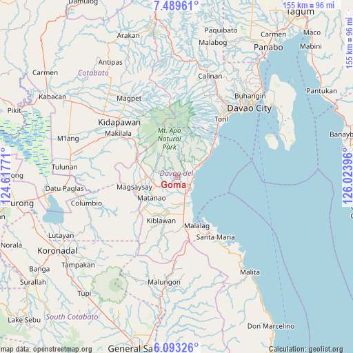
Goma GPS coordinates[2]
6° 47' 30.984" North, 125° 19' 14.988" East
| Map corner | latitude | longitude |
|---|---|---|
| Upper-left | 7.48961°, | 124.61771° |
| Center: | 6.79194°, | 125.32083° |
| Lower-right: | 6.09326°, | 126.02396° |
| Map W x H: | 155.3×155.3 km | = 96.5×96.5mi |
| max Lat: | 20.78733° ⇑93.3% North |
| Goma: | 6.79194° |
| min Lat: | ⇓6.7% South 4.65442° |
| min Long | Goma | max Long |
| 117.04868° | 125.32083° | 126.58417° |
| W 91.5%⇐ | ⇒8.5% E |
Elevation
Elevation of Goma is 80 m = 262 ft, and this is 7.9 m = 26 ft below average elevation for this country.
| Max E: |
2262 m = 7421 ft | 22% |
| Avg. | 87.9 m = 288 ft | |
| Goma | 80 m = 262 ft | |
Min E: |
-2 m = -7 ft | 78% |
See also: Philippines elevation on elevation.city.
Geographical zone
Goma is located in North Torrid zone (between Equator and Tropic of Cancer). Distance of Equator is 755.2 km =469.3 mi to South.| Distance of | km | miles | from Goma |
|---|---|---|---|
| North Pole | 9251.9 | 5748.9 | to North |
| Arctic Circle | 6646 | 4129.6 | to North |
| Tropic Cancer | 1850.7 | 1150 | to North |
| Equator | 755.2 | 469.3 | to South |


Nearby cities:
15 places around Goma: (largest is in red/bold)
• Balutakay
8.6 km =5.3 mi,  156°
156°
• Bansalan
11.9 km =7.4 mi,  266°
266°
• Digos
6.2 km =3.9 mi,  139°
139°
• Dolo
14.4 km =8.9 mi,  278°
278°
• Guihing Proper
12.5 km =7.8 mi, 163°
• Hagonoy
12.1 km =7.5 mi,  177°
177°
• Ignit
10.6 km =6.6 mi,  197°
197°
• Managa
7.7 km =4.8 mi,  228°
228°
• Matanao
14.5 km =9 mi,  210°
210°
• Matti
2.7 km =1.7 mi, 209°
• Santa Cruz
11.3 km =7 mi,  63°
63°
• Sinawilan
9.2 km =5.7 mi,  243°
243°
• Sinayawan
8.9 km =5.5 mi,  188°
188°
• Takub
13.3 km =8.3 mi, 57°
• Tuban
8.1 km =5 mi, 64°
Sources, notices
• [Note1] Compared only with cities in Philippines existing in our database
• [Src1] Map data: © OpenStreetMap contributors (CC-BY-SA)
• [Src2] Other city data from geonames.org with taken over terms of usage.
• [Src3] Geographical zone / Annual Mean Temperature by Robert A. Rohde @ Wikipedia
