Gamut geodata
Gamut (Caraga) is a populated place; located in Philippines in Asia/Manila (GMT+8) time zone. With population of 2,246 people, there are 3796 cities with bigger population in this country. Compared to other cities in Philippines, 75.8% of cities are located further ↑North; 98.9% of cities are located further ←West and 85.4% of cities have higher elevation than Gamut. Note1


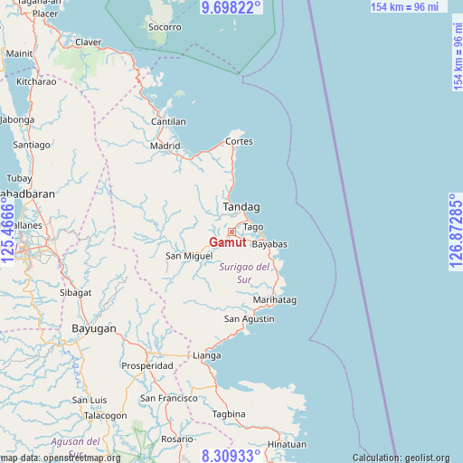
Gamut GPS coordinates[2]
9° 0' 15.984" North, 126° 10' 10.992" East
| Map corner | latitude | longitude |
|---|---|---|
| Upper-left | 9.69822°, | 125.4666° |
| Center: | 9.00444°, | 126.16972° |
| Lower-right: | 8.30933°, | 126.87285° |
| Map W x H: | 154.4×154.4 km | = 95.9×95.9mi |
| max Lat: | 20.78733° ⇑75.8% North |
| Gamut: | 9.00444° |
| min Lat: | ⇓24.2% South 4.65442° |
| min Long | Gamut | max Long |
| 117.04868° | 126.16972° | 126.58417° |
| W 98.9%⇐ | ⇒1.1% E |
Elevation
Elevation of Gamut is 8 m = 26 ft, and this is 79.9 m = 262 ft below average elevation for this country.
| Max E: |
2262 m = 7421 ft | 85.4% |
| Avg. | 87.9 m = 288 ft | |
| Gamut | 8 m = 26 ft | |
Min E: |
-2 m = -7 ft | 14.6% |
See also: Philippines elevation on elevation.city.
Geographical zone
Gamut is located in North Torrid zone (between Equator and Tropic of Cancer). Distance of Equator is 1001.2 km =622.1 mi to South.| Distance of | km | miles | from Gamut |
|---|---|---|---|
| North Pole | 9005.9 | 5596 | to North |
| Arctic Circle | 6400 | 3976.8 | to North |
| Tropic Cancer | 1604.7 | 997.1 | to North |
| Equator | 1001.2 | 622.1 | to South |


Nearby cities:
15 places around Gamut: (largest is in red/bold)
• Aras-asan
20.2 km =12.6 mi,  129°
129°
• Bacolod
15.4 km =9.6 mi,  121°
121°
• Bayabas
13.4 km =8.3 mi,  106°
106°
• Buenavista
12.3 km =7.6 mi,  355°
355°
• Burgos
29.2 km =18.1 mi,  4°
4°
• Cagwait
17.3 km =10.7 mi, 123°
• Carmen
29.8 km =18.5 mi,  325°
325°
• La Paz
10.5 km =6.5 mi,  102°
102°
• Lanuza
28 km =17.4 mi,  335°
335°
• Mabahin
20.1 km =12.5 mi, 0°
• Marihatag
26.1 km =16.2 mi,  147°
147°
• San Miguel
25 km =15.5 mi,  260°
260°
• Tago
7.1 km =4.4 mi,  74°
74°
• Tandag
8.8 km =5.5 mi,  21°
21°
• Tigao
22.7 km =14.1 mi, 1°
Sources, notices
• [Note1] Compared only with cities in Philippines existing in our database
• [Src1] Map data: © OpenStreetMap contributors (CC-BY-SA)
• [Src2] Other city data from geonames.org with taken over terms of usage.
• [Src3] Geographical zone / Annual Mean Temperature by Robert A. Rohde @ Wikipedia
