Buenavista geodata
Buenavista (Caraga) is a populated place; located in Philippines in Asia/Manila (GMT+8) time zone. With population of 2,564 people, there are 3178 cities with bigger population in this country. Compared to other cities in Philippines, 75.1% of cities are located further ↑North; 98.9% of cities are located further ←West and 73.2% of cities have higher elevation than Buenavista. Note1
Administrative division(s):
- Level 1: Caraga
- Level 2: Province of Surigao del Sur
- Level 3: City of Tandag


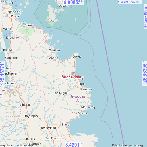
Buenavista GPS coordinates[2]
9° 6' 54" North, 126° 9' 38.988" East
| Map corner | latitude | longitude |
|---|---|---|
| Upper-left | 9.80855°, | 125.45771° |
| Center: | 9.115°, | 126.16083° |
| Lower-right: | 8.4201°, | 126.86396° |
| Map W x H: | 154.4×154.4 km | = 95.9×95.9mi |
| max Lat: | 20.78733° ⇑75.1% North |
| Buenavista: | 9.115° |
| min Lat: | ⇓24.9% South 4.65442° |
| min Long | Buenavista | max Long |
| 117.04868° | 126.16083° | 126.58417° |
| W 98.9%⇐ | ⇒1.1% E |
Elevation
Elevation of Buenavista is 11 m = 36 ft, and this is 76.9 m = 252 ft below average elevation for this country.
| Max E: |
2262 m = 7421 ft | 73.2% |
| Avg. | 87.9 m = 288 ft | |
| Buenavista | 11 m = 36 ft | |
Min E: |
-2 m = -7 ft | 26.8% |
See also: Philippines elevation on elevation.city.
Geographical zone
Buenavista is located in North Torrid zone (between Equator and Tropic of Cancer). Distance of Equator is 1013.5 km =629.8 mi to South.| Distance of | km | miles | from Buenavista |
|---|---|---|---|
| North Pole | 8993.6 | 5588.4 | to North |
| Arctic Circle | 6387.7 | 3969.1 | to North |
| Tropic Cancer | 1592.4 | 989.5 | to North |
| Equator | 1013.5 | 629.8 | to South |


Nearby cities:
15 places around Buenavista: (largest is in red/bold)
• Bacolod
24.8 km =15.4 mi,  145°
145°
• Bayabas
21.2 km =13.2 mi,  139°
139°
• Burgos
17.1 km =10.6 mi,  10°
10°
• Cagwait
26.7 km =16.6 mi, 144°
• Carmen
20 km =12.4 mi,  308°
308°
• Cortes
18.6 km =11.6 mi, 10°
• Gamut
12.3 km =7.6 mi,  175°
175°
• La Paz
18.3 km =11.4 mi, 142°
• Lanuza
17 km =10.6 mi,  321°
321°
• Mabahin
7.9 km =4.9 mi, 7°
• Madrid
27.1 km =16.8 mi, 307°
• San Miguel
28.7 km =17.8 mi,  235°
235°
• Tago
13 km =8.1 mi, 143°
• Tandag
5.8 km =3.6 mi,  134°
134°
• Tigao
10.6 km =6.6 mi, 9°
Sources, notices
• [Note1] Compared only with cities in Philippines existing in our database
• [Src1] Map data: © OpenStreetMap contributors (CC-BY-SA)
• [Src2] Other city data from geonames.org with taken over terms of usage.
• [Src3] Geographical zone / Annual Mean Temperature by Robert A. Rohde @ Wikipedia
