San Miguel geodata
San Miguel (Caraga) is a populated place; located in Philippines in Asia/Manila (GMT+8) time zone. With population of 2,983 people, there are 2547 cities with bigger population in this country. Compared to other cities in Philippines, 76.1% of cities are located further ↑North; 97.3% of cities are located further ←West and 65.9% of cities have lower elevation than San Miguel. Note1
Administrative division(s):
- Level 1: Caraga
- Level 2: Province of Surigao del Sur
- Level 3: San Miguel


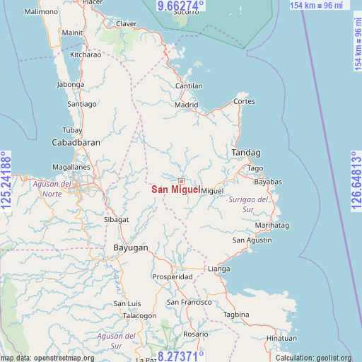
San Miguel GPS coordinates[2]
8° 58' 8.004" North, 125° 56' 42" East
| Map corner | latitude | longitude |
|---|---|---|
| Upper-left | 9.66274°, | 125.24188° |
| Center: | 8.96889°, | 125.945° |
| Lower-right: | 8.27371°, | 126.64813° |
| Map W x H: | 154.4×154.4 km | = 95.9×95.9mi |
| max Lat: | 20.78733° ⇑76.1% North |
| San Miguel: | 8.96889° |
| min Lat: | ⇓23.9% South 4.65442° |
| min Long | San Miguel | max Long |
| 117.04868° | 125.945° | 126.58417° |
| W 97.3%⇐ | ⇒2.7% E |
Elevation
Elevation of San Miguel is 43 m = 141 ft, and this is 44.9 m = 147 ft below average elevation for this country.
| Max E: |
2262 m = 7421 ft | 34.1% |
| Avg. | 87.9 m = 288 ft | |
| San Miguel | 43 m = 141 ft | |
Min E: |
-2 m = -7 ft | 65.9% |
See also: Philippines elevation on elevation.city.
Geographical zone
San Miguel is located in North Torrid zone (between Equator and Tropic of Cancer). Distance of Equator is 997.2 km =619.6 mi to South.| Distance of | km | miles | from San Miguel |
|---|---|---|---|
| North Pole | 9009.8 | 5598.4 | to North |
| Arctic Circle | 6403.9 | 3979.2 | to North |
| Tropic Cancer | 1608.7 | 999.6 | to North |
| Equator | 997.2 | 619.6 | to South |


Nearby cities:
15 places around San Miguel: (largest is in red/bold)
• Anticala
33.2 km =20.6 mi,  276°
276°
• Basag
35.8 km =22.2 mi,  262°
262°
• Bayugan
30.7 km =19.1 mi,  219°
219°
• Buenavista
28.7 km =17.8 mi,  55°
55°
• Carmen
29.7 km =18.5 mi,  15°
15°
• Gamut
25 km =15.5 mi,  80°
80°
• La Paz
35 km =21.7 mi,  87°
87°
• Lanuza
32.3 km =20.1 mi, 23°
• Mabahin
34.6 km =21.5 mi,  45°
45°
• Madrid
32.7 km =20.3 mi,  3°
3°
• Parang
34.8 km =21.6 mi,  359°
359°
• Sibagat
31.7 km =19.7 mi,  239°
239°
• Tago
32 km =19.9 mi, 79°
• Taligaman
32.6 km =20.3 mi, 257°
• Tandag
30.4 km =18.9 mi,  66°
66°
Sources, notices
• [Note1] Compared only with cities in Philippines existing in our database
• [Src1] Map data: © OpenStreetMap contributors (CC-BY-SA)
• [Src2] Other city data from geonames.org with taken over terms of usage.
• [Src3] Geographical zone / Annual Mean Temperature by Robert A. Rohde @ Wikipedia
