Tandag geodata
Tandag (Caraga) is a seat of a second-order administrative division; located in Philippines in Asia/Manila (GMT+8) time zone. With population of 29,011 people, there are 284 cities with bigger population in this country. Compared to other cities in Philippines, 75.4% of cities are located further ↑North; 99.1% of cities are located further ←West and 85.4% of cities have higher elevation than Tandag. Note1
Administrative division(s):
- Level 1: Caraga
- Level 2: Province of Surigao del Sur
- Level 3: City of Tandag


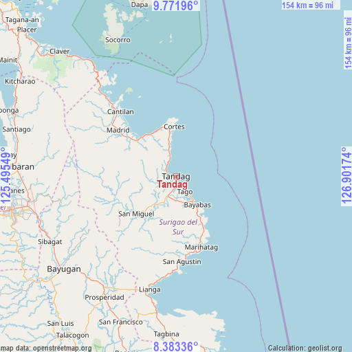
Tandag GPS coordinates[2]
9° 4' 41.988" North, 126° 11' 54.996" East
| Map corner | latitude | longitude |
|---|---|---|
| Upper-left | 9.77196°, | 125.49549° |
| Center: | 9.07833°, | 126.19861° |
| Lower-right: | 8.38336°, | 126.90174° |
| Map W x H: | 154.4×154.4 km | = 95.9×95.9mi |
| max Lat: | 20.78733° ⇑75.4% North |
| Tandag: | 9.07833° |
| min Lat: | ⇓24.6% South 4.65442° |
| min Long | Tandag | max Long |
| 117.04868° | 126.19861° | 126.58417° |
| W 99.1%⇐ | ⇒0.90000000000001% E |
Elevation
Elevation of Tandag is 8 m = 26 ft, and this is 79.9 m = 262 ft below average elevation for this country.
| Max E: |
2262 m = 7421 ft | 85.4% |
| Avg. | 87.9 m = 288 ft | |
| Tandag | 8 m = 26 ft | |
Min E: |
-2 m = -7 ft | 14.6% |
See also: Philippines elevation on elevation.city.
Geographical zone
Tandag is located in North Torrid zone (between Equator and Tropic of Cancer). Distance of Equator is 1009.4 km =627.2 mi to South.| Distance of | km | miles | from Tandag |
|---|---|---|---|
| North Pole | 8997.6 | 5590.8 | to North |
| Arctic Circle | 6391.8 | 3971.7 | to North |
| Tropic Cancer | 1596.5 | 992 | to North |
| Equator | 1009.4 | 627.2 | to South |


Nearby cities:
15 places around Tandag: (largest is in red/bold)
• Aras-asan
24.5 km =15.2 mi,  149°
149°
• Bacolod
19.1 km =11.9 mi, 148°
• Bayabas
15.4 km =9.6 mi,  141°
141°
• Buenavista
5.8 km =3.6 mi,  314°
314°
• Burgos
20.9 km =13 mi,  356°
356°
• Cagwait
21 km =13 mi, 147°
• Carmen
25.8 km =16 mi, 309°
• Cortes
22.4 km =13.9 mi, 357°
• Gamut
8.8 km =5.5 mi,  201°
201°
• La Paz
12.6 km =7.8 mi, 145°
• Lanuza
22.7 km =14.1 mi,  319°
319°
• Mabahin
12.3 km =7.6 mi,  345°
345°
• San Miguel
30.4 km =18.9 mi,  246°
246°
• Tago
7.3 km =4.5 mi, 150°
• Tigao
14.7 km =9.1 mi, 350°
Sources, notices
• [Note1] Compared only with cities in Philippines existing in our database
• [Src1] Map data: © OpenStreetMap contributors (CC-BY-SA)
• [Src2] Other city data from geonames.org with taken over terms of usage.
• [Src3] Geographical zone / Annual Mean Temperature by Robert A. Rohde @ Wikipedia
