Alabug geodata
Alabug (Cagayan Valley) is a populated place; located in Philippines in Asia/Manila (GMT+8) time zone. With population of 3,075 people, there are 2442 cities with bigger population in this country. Compared to other cities in Philippines, 97.5% of cities are located further ↓South; 67.1% of cities are located further →East and 62.9% of cities have lower elevation than Alabug. Note1


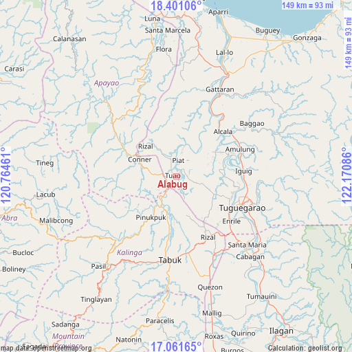
Alabug GPS coordinates[2]
17° 43' 57.396" North, 121° 28' 3.828" East
| Map corner | latitude | longitude |
|---|---|---|
| Upper-left | 18.40106°, | 120.76461° |
| Center: | 17.73261°, | 121.46773° |
| Lower-right: | 17.06165°, | 122.17086° |
| Map W x H: | 148.9×148.9 km | = 92.5×92.5mi |
| max Lat: | 20.78733° ⇑2.5% North |
| Alabug: | 17.73261° |
| min Lat: | ⇓97.5% South 4.65442° |
| min Long | Alabug | max Long |
| 117.04868° | 121.46773° | 126.58417° |
| W 32.9%⇐ | ⇒67.1% E |
Elevation
Elevation of Alabug is 38 m = 125 ft, and this is 49.9 m = 164 ft below average elevation for this country.
| Max E: |
2262 m = 7421 ft | 37.1% |
| Avg. | 87.9 m = 288 ft | |
| Alabug | 38 m = 125 ft | |
Min E: |
-2 m = -7 ft | 62.9% |
See also: Philippines elevation on elevation.city.
Geographical zone
Alabug is located in North Torrid zone (between Equator and Tropic of Cancer). Distance of this Northern Tropic circle is 634.2 km =394.1 mi to North.| Distance of | km | miles | from Alabug |
|---|---|---|---|
| North Pole | 8035.4 | 4993 | to North |
| Arctic Circle | 5429.5 | 3373.7 | to North |
| Tropic Cancer | 634.2 | 394.1 | to North |
| Equator | 1971.7 | 1225.2 | to South |


Nearby cities:
15 places around Alabug: (largest is in red/bold)
• Accusilian
1.8 km =1.1 mi,  342°
342°
• Bagumbayan
2.5 km =1.6 mi,  243°
243°
• Battung
1.4 km =0.9 mi,  219°
219°
• Conner
16.5 km =10.3 mi,  295°
295°
• Dagupan
5.3 km =3.3 mi,  132°
132°
• Gadu
19 km =11.8 mi, 127°
• Iraga
20.1 km =12.5 mi,  99°
99°
• Lallayug
4 km =2.5 mi, 223°
• Maguilling
5.2 km =3.2 mi,  37°
37°
• Mungo
1 km =0.6 mi,  160°
160°
• Pata
4.1 km =2.5 mi,  118°
118°
• Piat
6.5 km =4 mi,  9°
9°
• Pinukpuk
14.8 km =9.2 mi,  209°
209°
• Rizal
18.2 km =11.3 mi,  315°
315°
• Tuao
1.3 km =0.8 mi,  289°
289°
Sources, notices
• [Note1] Compared only with cities in Philippines existing in our database
• [Src1] Map data: © OpenStreetMap contributors (CC-BY-SA)
• [Src2] Other city data from geonames.org with taken over terms of usage.
• [Src3] Geographical zone / Annual Mean Temperature by Robert A. Rohde @ Wikipedia
