Lemery geodata
Lemery (Western Visayas) is a seat of a third-order administrative division; located in Philippines in Asia/Manila (GMT+8) time zone. With population of 3,240 people, there are 2268 cities with bigger population in this country. Compared to other cities in Philippines, 54.2% of cities are located further ↑North; 52% of cities are located further ←West and 79.7% of cities have lower elevation than Lemery. Note1


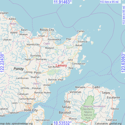
Lemery GPS coordinates[2]
11° 13' 32.88" North, 122° 55' 39" East
| Map corner | latitude | longitude |
|---|---|---|
| Upper-left | 11.91463°, | 122.22438° |
| Center: | 11.2258°, | 122.9275° |
| Lower-right: | 10.53532°, | 123.63063° |
| Map W x H: | 153.4×153.4 km | = 95.3×95.3mi |
| max Lat: | 20.78733° ⇑54.2% North |
| Lemery: | 11.2258° |
| min Lat: | ⇓45.8% South 4.65442° |
| min Long | Lemery | max Long |
| 117.04868° | 122.9275° | 126.58417° |
| W 52%⇐ | ⇒48% E |
Elevation
Elevation of Lemery is 90 m = 295 ft, and this is 2.1 m = 7 ft above average elevation for this country.
| Max E: |
2262 m = 7421 ft | 20.3% |
| Lemery | 90 m 295 ft | |
| Avg. | 87.9 m = 288 ft | |
Min E: |
-2 m = -7 ft | 79.7% |
See also: Philippines elevation on elevation.city.
Geographical zone
Lemery is located in North Torrid zone (between Equator and Tropic of Cancer). Distance of Equator is 1248.2 km =775.6 mi to South.| Distance of | km | miles | from Lemery |
|---|---|---|---|
| North Pole | 8758.9 | 5442.5 | to North |
| Arctic Circle | 6153 | 3823.3 | to North |
| Tropic Cancer | 1357.7 | 843.6 | to North |
| Equator | 1248.2 | 775.6 | to South |


Nearby cities:
15 places around Lemery: (largest is in red/bold)
• Ajuy
11.7 km =7.3 mi,  120°
120°
• Anoring
11.9 km =7.4 mi,  76°
76°
• Asturga
14.1 km =8.8 mi,  283°
283°
• Bay-ang
21.3 km =13.2 mi,  175°
175°
• Concepcion
19.6 km =12.2 mi,  93°
93°
• Culasi
17.4 km =10.8 mi,  159°
159°
• Gibato
12.3 km =7.6 mi,  269°
269°
• Lantangan
18.3 km =11.4 mi,  346°
346°
• Malayo-an
16.8 km =10.4 mi,  147°
147°
• Pili
15.2 km =9.4 mi,  141°
141°
• Quipot
10.2 km =6.3 mi,  51°
51°
• San Dionisio
19.1 km =11.9 mi,  74°
74°
• San Rafael
12.1 km =7.5 mi,  244°
244°
• Santiago
18.7 km =11.6 mi,  185°
185°
• Sara
10.1 km =6.3 mi, 69°
Sources, notices
• [Note1] Compared only with cities in Philippines existing in our database
• [Src1] Map data: © OpenStreetMap contributors (CC-BY-SA)
• [Src2] Other city data from geonames.org with taken over terms of usage.
• [Src3] Geographical zone / Annual Mean Temperature by Robert A. Rohde @ Wikipedia
