San Rafael geodata
San Rafael (Western Visayas) is a seat of a third-order administrative division; located in Philippines in Asia/Manila (GMT+8) time zone. With population of 3,492 people, there are 2059 cities with bigger population in this country. Compared to other cities in Philippines, 54.8% of cities are located further ↑North; 50.2% of cities are located further ←West and 83.6% of cities have lower elevation than San Rafael. Note1
Administrative division(s):
- Level 1: Western Visayas
- Level 2: Province of Iloilo
- Level 3: San Rafael


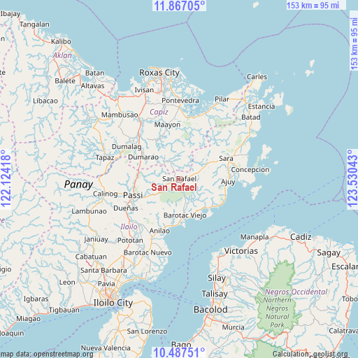
San Rafael GPS coordinates[2]
11° 10' 41.16" North, 122° 49' 38.28" East
| Map corner | latitude | longitude |
|---|---|---|
| Upper-left | 11.86705°, | 122.12418° |
| Center: | 11.1781°, | 122.8273° |
| Lower-right: | 10.48751°, | 123.53043° |
| Map W x H: | 153.4×153.4 km | = 95.3×95.3mi |
| max Lat: | 20.78733° ⇑54.8% North |
| San Rafael: | 11.1781° |
| min Lat: | ⇓45.2% South 4.65442° |
| min Long | San Rafael | max Long |
| 117.04868° | 122.8273° | 126.58417° |
| W 50.2%⇐ | ⇒49.8% E |
Elevation
Elevation of San Rafael is 122 m = 400 ft, and this is 34.1 m = 112 ft above average elevation for this country.
| Max E: |
2262 m = 7421 ft | 16.4% |
| San Rafael | 122 m 400 ft | |
| Avg. | 87.9 m = 288 ft | |
Min E: |
-2 m = -7 ft | 83.6% |
See also: Philippines elevation on elevation.city.
Geographical zone
San Rafael is located in North Torrid zone (between Equator and Tropic of Cancer). Distance of Equator is 1242.9 km =772.3 mi to South.| Distance of | km | miles | from San Rafael |
|---|---|---|---|
| North Pole | 8764.2 | 5445.8 | to North |
| Arctic Circle | 6158.3 | 3826.6 | to North |
| Tropic Cancer | 1363 | 846.9 | to North |
| Equator | 1242.9 | 772.3 | to South |


Nearby cities:
15 places around San Rafael: (largest is in red/bold)
• Abaca
13.1 km =8.1 mi,  248°
248°
• Aglalana
18.5 km =11.5 mi,  270°
270°
• Alimono
12.5 km =7.8 mi, 273°
• Asturga
8.9 km =5.5 mi,  341°
341°
• Barotac Viejo
15.4 km =9.6 mi,  169°
169°
• Bungsuan
15.8 km =9.8 mi,  296°
296°
• Carmelo
18 km =11.2 mi,  183°
183°
• De la Paz
13.7 km =8.5 mi,  202°
202°
• Dumarao
17.9 km =11.1 mi, 302°
• Gibato
5.4 km =3.4 mi, 344°
• Jaguimitan
12.1 km =7.5 mi, 249°
• Lemery
12.1 km =7.5 mi,  64°
64°
• Libertad
17.1 km =10.6 mi, 201°
• Mapili
12.4 km =7.7 mi,  230°
230°
• Santiago
16.2 km =10.1 mi,  145°
145°
Sources, notices
• [Note1] Compared only with cities in Philippines existing in our database
• [Src1] Map data: © OpenStreetMap contributors (CC-BY-SA)
• [Src2] Other city data from geonames.org with taken over terms of usage.
• [Src3] Geographical zone / Annual Mean Temperature by Robert A. Rohde @ Wikipedia
