Culasian geodata
Culasian (Eastern Visayas) is a populated place; located in Philippines in Asia/Manila (GMT+8) time zone. With population of 2,475 people, there are 3339 cities with bigger population in this country. Compared to other cities in Philippines, 53.1% of cities are located further ↑North; 81% of cities are located further ←West and 85.4% of cities have higher elevation than Culasian. Note1


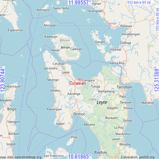
Culasian GPS coordinates[2]
11° 18' 24.984" North, 124° 36' 38.016" East
| Map corner | latitude | longitude |
|---|---|---|
| Upper-left | 11.99557°, | 123.90744° |
| Center: | 11.30694°, | 124.61056° |
| Lower-right: | 10.61665°, | 125.31369° |
| Map W x H: | 153.3×153.3 km | = 95.3×95.3mi |
| max Lat: | 20.78733° ⇑53.1% North |
| Culasian: | 11.30694° |
| min Lat: | ⇓46.9% South 4.65442° |
| min Long | Culasian | max Long |
| 117.04868° | 124.61056° | 126.58417° |
| W 81%⇐ | ⇒19% E |
Elevation
Elevation of Culasian is 8 m = 26 ft, and this is 79.9 m = 262 ft below average elevation for this country.
| Max E: |
2262 m = 7421 ft | 85.4% |
| Avg. | 87.9 m = 288 ft | |
| Culasian | 8 m = 26 ft | |
Min E: |
-2 m = -7 ft | 14.6% |
See also: Philippines elevation on elevation.city.
Geographical zone
Culasian is located in North Torrid zone (between Equator and Tropic of Cancer). Distance of Equator is 1257.2 km =781.2 mi to South.| Distance of | km | miles | from Culasian |
|---|---|---|---|
| North Pole | 8749.8 | 5436.9 | to North |
| Arctic Circle | 6144 | 3817.7 | to North |
| Tropic Cancer | 1348.7 | 838 | to North |
| Equator | 1257.2 | 781.2 | to South |


Nearby cities:
15 places around Culasian: (largest is in red/bold)
• Barugo
14.1 km =8.8 mi,  82°
82°
• Butazon
16.2 km =10.1 mi,  270°
270°
• Capoocan
3.7 km =2.3 mi,  113°
113°
• Carigara
7.5 km =4.7 mi,  97°
97°
• Consuegra
10.8 km =6.7 mi,  264°
264°
• Guindapunan
10.4 km =6.5 mi,  92°
92°
• Kananya
14.5 km =9 mi,  202°
202°
• Leyte
15.5 km =9.6 mi,  295°
295°
• Lim-oo
17.5 km =10.9 mi,  172°
172°
• Limon
5.1 km =3.2 mi,  247°
247°
• Naghalin
18.6 km =11.6 mi,  194°
194°
• Palaroo
17.7 km =11 mi,  308°
308°
• Pinamopoan
4.1 km =2.5 mi,  282°
282°
• Rizal
14.9 km =9.3 mi, 193°
• Tunga
16.8 km =10.4 mi, 113°
Sources, notices
• [Note1] Compared only with cities in Philippines existing in our database
• [Src1] Map data: © OpenStreetMap contributors (CC-BY-SA)
• [Src2] Other city data from geonames.org with taken over terms of usage.
• [Src3] Geographical zone / Annual Mean Temperature by Robert A. Rohde @ Wikipedia
