Rizal geodata
Rizal (Eastern Visayas) is a populated place; located in Philippines in Asia/Manila (GMT+8) time zone. With population of 3,835 people, there are 1821 cities with bigger population in this country. Compared to other cities in Philippines, 54.8% of cities are located further ↑North; 80.3% of cities are located further ←West and 79.7% of cities have lower elevation than Rizal. Note1


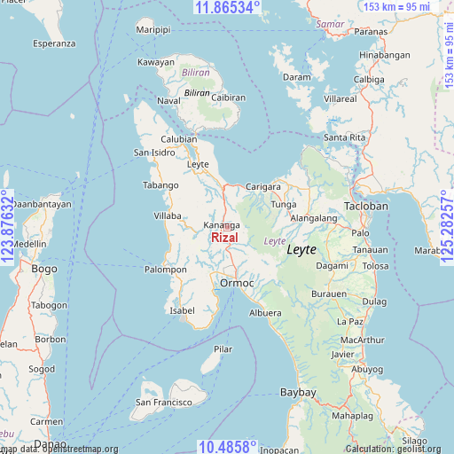
Rizal GPS coordinates[2]
11° 10' 35.004" North, 124° 34' 45.984" East
| Map corner | latitude | longitude |
|---|---|---|
| Upper-left | 11.86534°, | 123.87632° |
| Center: | 11.17639°, | 124.57944° |
| Lower-right: | 10.4858°, | 125.28257° |
| Map W x H: | 153.4×153.4 km | = 95.3×95.3mi |
| max Lat: | 20.78733° ⇑54.8% North |
| Rizal: | 11.17639° |
| min Lat: | ⇓45.2% South 4.65442° |
| min Long | Rizal | max Long |
| 117.04868° | 124.57944° | 126.58417° |
| W 80.3%⇐ | ⇒19.7% E |
Elevation
Elevation of Rizal is 90 m = 295 ft, and this is 2.1 m = 7 ft above average elevation for this country.
| Max E: |
2262 m = 7421 ft | 20.3% |
| Rizal | 90 m 295 ft | |
| Avg. | 87.9 m = 288 ft | |
Min E: |
-2 m = -7 ft | 79.7% |
See also: Philippines elevation on elevation.city.
Geographical zone
Rizal is located in North Torrid zone (between Equator and Tropic of Cancer). Distance of Equator is 1242.7 km =772.2 mi to South.| Distance of | km | miles | from Rizal |
|---|---|---|---|
| North Pole | 8764.4 | 5445.9 | to North |
| Arctic Circle | 6158.5 | 3826.7 | to North |
| Tropic Cancer | 1363.2 | 847.1 | to North |
| Equator | 1242.7 | 772.2 | to South |


Nearby cities:
15 places around Rizal: (largest is in red/bold)
• Balagtas
8.1 km =5 mi,  233°
233°
• Capoocan
14.7 km =9.1 mi,  27°
27°
• Consuegra
15.3 km =9.5 mi,  331°
331°
• Culasian
14.9 km =9.3 mi,  13°
13°
• Dolores
13.3 km =8.3 mi,  163°
163°
• Kananya
2.4 km =1.5 mi,  298°
298°
• Liloan
15 km =9.3 mi,  192°
192°
• Lim-oo
6.3 km =3.9 mi,  116°
116°
• Limon
12.6 km =7.8 mi,  353°
353°
• Malilinao
11.5 km =7.1 mi, 227°
• Masarayao
10.5 km =6.5 mi, 156°
• Naghalin
3.7 km =2.3 mi,  201°
201°
• San Vicente
6.6 km =4.1 mi, 193°
• Santo Niño
12.7 km =7.9 mi, 188°
• Valencia
7.5 km =4.7 mi, 185°
Sources, notices
• [Note1] Compared only with cities in Philippines existing in our database
• [Src1] Map data: © OpenStreetMap contributors (CC-BY-SA)
• [Src2] Other city data from geonames.org with taken over terms of usage.
• [Src3] Geographical zone / Annual Mean Temperature by Robert A. Rohde @ Wikipedia
