Concepcion geodata
Concepcion (Central Luzon) is a populated place; located in Philippines in Asia/Manila (GMT+8) time zone. With population of 3,196 people, there are 2308 cities with bigger population in this country. Compared to other cities in Philippines, 79.4% of cities are located further ↓South; 81.5% of cities are located further →East and 67.4% of cities have higher elevation than Concepcion. Note1


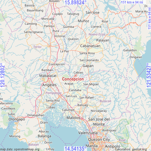
Concepcion GPS coordinates[2]
15° 13' 15.204" North, 120° 49' 52.104" East
| Map corner | latitude | longitude |
|---|---|---|
| Upper-left | 15.89824°, | 120.12802° |
| Center: | 15.22089°, | 120.83114° |
| Lower-right: | 14.54135°, | 121.53427° |
| Map W x H: | 150.9×150.9 km | = 93.8×93.8mi |
| max Lat: | 20.78733° ⇑20.6% North |
| Concepcion: | 15.22089° |
| min Lat: | ⇓79.4% South 4.65442° |
| min Long | Concepcion | max Long |
| 117.04868° | 120.83114° | 126.58417° |
| W 18.5%⇐ | ⇒81.5% E |
Elevation
Elevation of Concepcion is 13 m = 43 ft, and this is 74.9 m = 246 ft below average elevation for this country.
| Max E: |
2262 m = 7421 ft | 67.4% |
| Avg. | 87.9 m = 288 ft | |
| Concepcion | 13 m = 43 ft | |
Min E: |
-2 m = -7 ft | 32.6% |
See also: Philippines elevation on elevation.city.
Geographical zone
Concepcion is located in North Torrid zone (between Equator and Tropic of Cancer). Distance of this Northern Tropic circle is 913.5 km =567.6 mi to North.| Distance of | km | miles | from Concepcion |
|---|---|---|---|
| North Pole | 8314.7 | 5166.5 | to North |
| Arctic Circle | 5708.8 | 3547.3 | to North |
| Tropic Cancer | 913.5 | 567.6 | to North |
| Equator | 1692.4 | 1051.6 | to South |


Nearby cities:
15 places around Concepcion: (largest is in red/bold)
• Arayat
10.2 km =6.3 mi,  220°
220°
• Buliran Segundo
6.4 km =4 mi,  36°
36°
• Cabiao
4 km =2.5 mi, 39°
• Calaba
10 km =6.2 mi,  27°
27°
• Candating
7.9 km =4.9 mi,  189°
189°
• Entablado
8.1 km =5 mi, 25°
• Mandili
6.8 km =4.2 mi,  133°
133°
• Mangga
9 km =5.6 mi,  68°
68°
• San Antonio
9.9 km =6.2 mi,  15°
15°
• San Mateo
4.6 km =2.9 mi,  239°
239°
• San Vicente
1.6 km =1 mi, 236°
• Santa Cruz
10 km =6.2 mi,  13°
13°
• Santo Cristo
10.6 km =6.6 mi, 36°
• Tabon
10.4 km =6.5 mi,  57°
57°
• Tikiw
10.6 km =6.6 mi, 17°
Sources, notices
• [Note1] Compared only with cities in Philippines existing in our database
• [Src1] Map data: © OpenStreetMap contributors (CC-BY-SA)
• [Src2] Other city data from geonames.org with taken over terms of usage.
• [Src3] Geographical zone / Annual Mean Temperature by Robert A. Rohde @ Wikipedia
