San Mateo geodata
San Mateo (Central Luzon) is a populated place; located in Philippines in Asia/Manila (GMT+8) time zone. With population of 4,984 people, there are 1304 cities with bigger population in this country. Compared to other cities in Philippines, 79.2% of cities are located further ↓South; 82.4% of cities are located further →East and 60.8% of cities have higher elevation than San Mateo. Note1


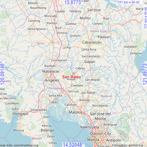
San Mateo GPS coordinates[2]
15° 12' 0.288" North, 120° 47' 40.56" East
| Map corner | latitude | longitude |
|---|---|---|
| Upper-left | 15.8775°, | 120.09148° |
| Center: | 15.20008°, | 120.7946° |
| Lower-right: | 14.52048°, | 121.49773° |
| Map W x H: | 150.9×150.9 km | = 93.8×93.8mi |
| max Lat: | 20.78733° ⇑20.8% North |
| San Mateo: | 15.20008° |
| min Lat: | ⇓79.2% South 4.65442° |
| min Long | San Mateo | max Long |
| 117.04868° | 120.7946° | 126.58417° |
| W 17.6%⇐ | ⇒82.4% E |
Elevation
Elevation of San Mateo is 16 m = 52 ft, and this is 71.9 m = 236 ft below average elevation for this country.
| Max E: |
2262 m = 7421 ft | 60.8% |
| Avg. | 87.9 m = 288 ft | |
| San Mateo | 16 m = 52 ft | |
Min E: |
-2 m = -7 ft | 39.2% |
See also: Philippines elevation on elevation.city.
Geographical zone
San Mateo is located in North Torrid zone (between Equator and Tropic of Cancer). Distance of this Northern Tropic circle is 915.8 km =569.1 mi to North.| Distance of | km | miles | from San Mateo |
|---|---|---|---|
| North Pole | 8317 | 5167.9 | to North |
| Arctic Circle | 5711.1 | 3548.7 | to North |
| Tropic Cancer | 915.8 | 569.1 | to North |
| Equator | 1690.1 | 1050.2 | to South |


Nearby cities:
15 places around San Mateo: (largest is in red/bold)
• Arayat
6.1 km =3.8 mi,  205°
205°
• Arenas
12.1 km =7.5 mi,  254°
254°
• Buliran Segundo
10.7 km =6.6 mi,  46°
46°
• Cabiao
8.4 km =5.2 mi, 50°
• Candaba
12.1 km =7.5 mi,  163°
163°
• Candating
6.1 km =3.8 mi, 155°
• Concepcion
4.6 km =2.9 mi,  59°
59°
• Entablado
12.1 km =7.5 mi,  37°
37°
• Mandili
9.2 km =5.7 mi,  104°
104°
• Panlinlang
10.3 km =6.4 mi,  259°
259°
• San Antonio
12.6 km =7.8 mi, 245°
• San Vicente
3 km =1.9 mi, 60°
• Santa Ana
12 km =7.5 mi,  194°
194°
• Santo Niño
9.7 km =6 mi,  294°
294°
• Tal I Mun Doc
11.8 km =7.3 mi,  276°
276°
Sources, notices
• [Note1] Compared only with cities in Philippines existing in our database
• [Src1] Map data: © OpenStreetMap contributors (CC-BY-SA)
• [Src2] Other city data from geonames.org with taken over terms of usage.
• [Src3] Geographical zone / Annual Mean Temperature by Robert A. Rohde @ Wikipedia
