Mandili geodata
Mandili (Central Luzon) is a populated place; located in Philippines in Asia/Manila (GMT+8) time zone. With population of 4,532 people, there are 1475 cities with bigger population in this country. Compared to other cities in Philippines, 79.1% of cities are located further ↓South; 80.1% of cities are located further →East and 76.6% of cities have higher elevation than Mandili. Note1


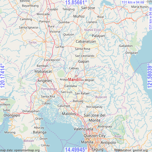
Mandili GPS coordinates[2]
15° 10' 44.832" North, 120° 52' 38.136" East
| Map corner | latitude | longitude |
|---|---|---|
| Upper-left | 15.85661°, | 120.17414° |
| Center: | 15.17912°, | 120.87726° |
| Lower-right: | 14.49945°, | 121.58039° |
| Map W x H: | 150.9×150.9 km | = 93.8×93.8mi |
| max Lat: | 20.78733° ⇑20.9% North |
| Mandili: | 15.17912° |
| min Lat: | ⇓79.1% South 4.65442° |
| min Long | Mandili | max Long |
| 117.04868° | 120.87726° | 126.58417° |
| W 19.9%⇐ | ⇒80.1% E |
Elevation
Elevation of Mandili is 10 m = 33 ft, and this is 77.9 m = 256 ft below average elevation for this country.
| Max E: |
2262 m = 7421 ft | 76.6% |
| Avg. | 87.9 m = 288 ft | |
| Mandili | 10 m = 33 ft | |
Min E: |
-2 m = -7 ft | 23.4% |
See also: Philippines elevation on elevation.city.
Geographical zone
Mandili is located in North Torrid zone (between Equator and Tropic of Cancer). Distance of this Northern Tropic circle is 918.2 km =570.5 mi to North.| Distance of | km | miles | from Mandili |
|---|---|---|---|
| North Pole | 8319.3 | 5169.4 | to North |
| Arctic Circle | 5713.4 | 3550.1 | to North |
| Tropic Cancer | 918.2 | 570.5 | to North |
| Equator | 1687.8 | 1048.7 | to South |


Nearby cities:
15 places around Mandili: (largest is in red/bold)
• Batasan Bata
7.8 km =4.8 mi,  119°
119°
• Buliran Segundo
9.8 km =6.1 mi,  353°
353°
• Bulualto
9.4 km =5.8 mi,  60°
60°
• Cabiao
8.1 km =5 mi,  342°
342°
• Camias
10.5 km =6.5 mi,  97°
97°
• Candaba
10.8 km =6.7 mi,  210°
210°
• Candating
7.1 km =4.4 mi,  243°
243°
• Concepcion
6.8 km =4.2 mi,  313°
313°
• Mangga
8.6 km =5.3 mi,  23°
23°
• Mapaniqui
9.4 km =5.8 mi,  148°
148°
• Pulo
9.2 km =5.7 mi,  36°
36°
• Salapungan
7.4 km =4.6 mi,  132°
132°
• San Mateo
9.2 km =5.7 mi,  284°
284°
• San Vicente
7.3 km =4.5 mi,  301°
301°
• Tabon
10.9 km =6.8 mi, 20°
Sources, notices
• [Note1] Compared only with cities in Philippines existing in our database
• [Src1] Map data: © OpenStreetMap contributors (CC-BY-SA)
• [Src2] Other city data from geonames.org with taken over terms of usage.
• [Src3] Geographical zone / Annual Mean Temperature by Robert A. Rohde @ Wikipedia
