Concepcion geodata
Concepcion (Mimaropa) is a seat of a third-order administrative division; located in Philippines in Asia/Manila (GMT+8) time zone. With population of 4,686 people, there are 1418 cities with bigger population in this country. Compared to other cities in Philippines, 54.1% of cities are located further ↓South; 59% of cities are located further →East and 75.8% of cities have lower elevation than Concepcion. Note1
Administrative division(s):
- Level 1: Mimaropa
- Level 2: Province of Romblon
- Level 3: Santa Maria (Imelda)


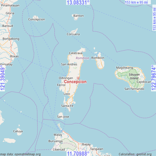
Concepcion GPS coordinates[2]
12° 23' 51" North, 122° 5' 36.996" East
| Map corner | latitude | longitude |
|---|---|---|
| Upper-left | 13.08331°, | 121.39049° |
| Center: | 12.3975°, | 122.09361° |
| Lower-right: | 11.70988°, | 122.79674° |
| Map W x H: | 152.7×152.7 km | = 94.9×94.9mi |
| max Lat: | 20.78733° ⇑45.9% North |
| Concepcion: | 12.3975° |
| min Lat: | ⇓54.1% South 4.65442° |
| min Long | Concepcion | max Long |
| 117.04868° | 122.09361° | 126.58417° |
| W 41%⇐ | ⇒59% E |
Elevation
Elevation of Concepcion is 71 m = 233 ft, and this is 16.9 m = 55 ft below average elevation for this country.
| Max E: |
2262 m = 7421 ft | 24.2% |
| Avg. | 87.9 m = 288 ft | |
| Concepcion | 71 m = 233 ft | |
Min E: |
-2 m = -7 ft | 75.8% |
See also: Philippines elevation on elevation.city.
Geographical zone
Concepcion is located in North Torrid zone (between Equator and Tropic of Cancer). Distance of this Northern Tropic circle is 1227.4 km =762.7 mi to North.| Distance of | km | miles | from Concepcion |
|---|---|---|---|
| North Pole | 8628.6 | 5361.6 | to North |
| Arctic Circle | 6022.7 | 3742.3 | to North |
| Tropic Cancer | 1227.4 | 762.7 | to North |
| Equator | 1378.5 | 856.6 | to South |


Nearby cities:
15 places around Concepcion: (largest is in red/bold)
• Alcantara
16 km =9.9 mi,  195°
195°
• Dapawan
7.2 km =4.5 mi,  278°
278°
• Dobdoban
19.8 km =12.3 mi,  6°
6°
• Ferrol
17.8 km =11.1 mi,  248°
248°
• Gabawan
9.3 km =5.8 mi,  290°
290°
• Libertad
11.2 km =7 mi,  304°
304°
• Limon
13.7 km =8.5 mi,  217°
217°
• Looc
18.8 km =11.7 mi, 215°
• Odiongan
11.1 km =6.9 mi,  272°
272°
• Panique
12.6 km =7.8 mi,  317°
317°
• Pato-o
4.7 km =2.9 mi, 320°
• Punta
19.3 km =12 mi,  208°
208°
• San Agustin
19.5 km =12.1 mi, 12°
• Tomingad
9.4 km =5.8 mi, 302°
• Tugdan
9.4 km =5.8 mi,  185°
185°
Sources, notices
• [Note1] Compared only with cities in Philippines existing in our database
• [Src1] Map data: © OpenStreetMap contributors (CC-BY-SA)
• [Src2] Other city data from geonames.org with taken over terms of usage.
• [Src3] Geographical zone / Annual Mean Temperature by Robert A. Rohde @ Wikipedia
