Libertad geodata
Libertad (Mimaropa) is a populated place; located in Philippines in Asia/Manila (GMT+8) time zone. With population of 2,231 people, there are 3821 cities with bigger population in this country. Compared to other cities in Philippines, 54.5% of cities are located further ↓South; 60.2% of cities are located further →East and 56.6% of cities have lower elevation than Libertad. Note1


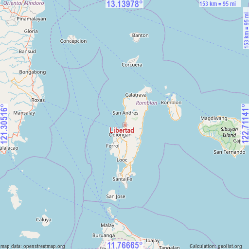
Libertad GPS coordinates[2]
12° 27' 14.832" North, 122° 0' 29.808" East
| Map corner | latitude | longitude |
|---|---|---|
| Upper-left | 13.13978°, | 121.30516° |
| Center: | 12.45412°, | 122.00828° |
| Lower-right: | 11.76665°, | 122.71141° |
| Map W x H: | 152.7×152.7 km | = 94.9×94.9mi |
| max Lat: | 20.78733° ⇑45.5% North |
| Libertad: | 12.45412° |
| min Lat: | ⇓54.5% South 4.65442° |
| min Long | Libertad | max Long |
| 117.04868° | 122.00828° | 126.58417° |
| W 39.8%⇐ | ⇒60.2% E |
Elevation
Elevation of Libertad is 29 m = 95 ft, and this is 58.9 m = 193 ft below average elevation for this country.
| Max E: |
2262 m = 7421 ft | 43.4% |
| Avg. | 87.9 m = 288 ft | |
| Libertad | 29 m = 95 ft | |
Min E: |
-2 m = -7 ft | 56.6% |
See also: Philippines elevation on elevation.city.
Geographical zone
Libertad is located in North Torrid zone (between Equator and Tropic of Cancer). Distance of this Northern Tropic circle is 1221.2 km =758.8 mi to North.| Distance of | km | miles | from Libertad |
|---|---|---|---|
| North Pole | 8622.3 | 5357.6 | to North |
| Arctic Circle | 6016.4 | 3738.4 | to North |
| Tropic Cancer | 1221.2 | 758.8 | to North |
| Equator | 1384.8 | 860.5 | to South |


Nearby cities:
15 places around Libertad: (largest is in red/bold)
• Calatrava
19.7 km =12.2 mi,  20°
20°
• Carmen
21.9 km =13.6 mi,  34°
34°
• Concepcion
11.2 km =7 mi,  124°
124°
• Dapawan
5.7 km =3.5 mi,  158°
158°
• Dobdoban
17.6 km =10.9 mi,  40°
40°
• Ferrol
14.8 km =9.2 mi,  209°
209°
• Gabawan
3 km =1.9 mi,  169°
169°
• Limon
17.2 km =10.7 mi,  176°
176°
• Looc
21.6 km =13.4 mi, 184°
• Odiongan
6.1 km =3.8 mi,  196°
196°
• Panique
3 km =1.9 mi,  13°
13°
• Pato-o
6.8 km =4.2 mi,  112°
112°
• San Agustin
18.5 km =11.5 mi,  46°
46°
• Tomingad
1.9 km =1.2 mi,  131°
131°
• Tugdan
17.7 km =11 mi,  151°
151°
Sources, notices
• [Note1] Compared only with cities in Philippines existing in our database
• [Src1] Map data: © OpenStreetMap contributors (CC-BY-SA)
• [Src2] Other city data from geonames.org with taken over terms of usage.
• [Src3] Geographical zone / Annual Mean Temperature by Robert A. Rohde @ Wikipedia
