San Agustin geodata
San Agustin (Mimaropa) is a seat of a third-order administrative division; located in Philippines in Asia/Manila (GMT+8) time zone. With population of 4,258 people, there are 1608 cities with bigger population in this country. Compared to other cities in Philippines, 55.3% of cities are located further ↓South; 58.7% of cities are located further →East and 85.4% of cities have higher elevation than San Agustin. Note1


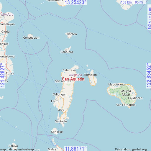
San Agustin GPS coordinates[2]
12° 34' 8.004" North, 122° 7' 53.004" East
| Map corner | latitude | longitude |
|---|---|---|
| Upper-left | 13.25423°, | 121.42827° |
| Center: | 12.56889°, | 122.13139° |
| Lower-right: | 11.88171°, | 122.83452° |
| Map W x H: | 152.6×152.6 km | = 94.8×94.8mi |
| max Lat: | 20.78733° ⇑44.7% North |
| San Agustin: | 12.56889° |
| min Lat: | ⇓55.3% South 4.65442° |
| min Long | San Agustin | max Long |
| 117.04868° | 122.13139° | 126.58417° |
| W 41.3%⇐ | ⇒58.7% E |
Elevation
Elevation of San Agustin is 8 m = 26 ft, and this is 79.9 m = 262 ft below average elevation for this country.
| Max E: |
2262 m = 7421 ft | 85.4% |
| Avg. | 87.9 m = 288 ft | |
| San Agustin | 8 m = 26 ft | |
Min E: |
-2 m = -7 ft | 14.6% |
See also: Philippines elevation on elevation.city.
Geographical zone
San Agustin is located in North Torrid zone (between Equator and Tropic of Cancer). Distance of this Northern Tropic circle is 1208.4 km =750.9 mi to North.| Distance of | km | miles | from San Agustin |
|---|---|---|---|
| North Pole | 8609.5 | 5349.7 | to North |
| Arctic Circle | 6003.6 | 3730.5 | to North |
| Tropic Cancer | 1208.4 | 750.9 | to North |
| Equator | 1397.5 | 868.4 | to South |


Nearby cities:
15 places around San Agustin: (largest is in red/bold)
• Alad
13.7 km =8.5 mi,  67°
67°
• Cajimos
15.9 km =9.9 mi,  79°
79°
• Calatrava
8.6 km =5.3 mi,  311°
311°
• Carmen
5.5 km =3.4 mi,  348°
348°
• Concepcion
19.5 km =12.1 mi,  192°
192°
• Corcuera
25.5 km =15.8 mi,  339°
339°
• Dapawan
21.2 km =13.2 mi,  211°
211°
• Dobdoban
2 km =1.2 mi,  288°
288°
• Gabawan
20.3 km =12.6 mi,  219°
219°
• Libertad
18.5 km =11.5 mi,  226°
226°
• Odiongan
24 km =14.9 mi, 219°
• Panique
16.1 km =10 mi, 232°
• Pato-o
17 km =10.6 mi,  204°
204°
• Romblon
15.1 km =9.4 mi,  87°
87°
• Tomingad
18.4 km =11.4 mi, 220°
Sources, notices
• [Note1] Compared only with cities in Philippines existing in our database
• [Src1] Map data: © OpenStreetMap contributors (CC-BY-SA)
• [Src2] Other city data from geonames.org with taken over terms of usage.
• [Src3] Geographical zone / Annual Mean Temperature by Robert A. Rohde @ Wikipedia
