Panique geodata
Panique (Mimaropa) is a populated place; located in Philippines in Asia/Manila (GMT+8) time zone. With population of 2,690 people, there are 2961 cities with bigger population in this country. Compared to other cities in Philippines, 54.6% of cities are located further ↓South; 60.1% of cities are located further →East and 80.7% of cities have higher elevation than Panique. Note1


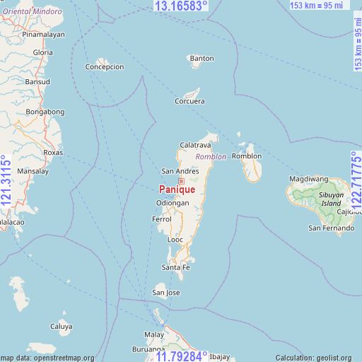
Panique GPS coordinates[2]
12° 28' 48.9" North, 122° 0' 52.632" East
| Map corner | latitude | longitude |
|---|---|---|
| Upper-left | 13.16583°, | 121.3115° |
| Center: | 12.48025°, | 122.01462° |
| Lower-right: | 11.79284°, | 122.71775° |
| Map W x H: | 152.7×152.7 km | = 94.9×94.9mi |
| max Lat: | 20.78733° ⇑45.4% North |
| Panique: | 12.48025° |
| min Lat: | ⇓54.6% South 4.65442° |
| min Long | Panique | max Long |
| 117.04868° | 122.01462° | 126.58417° |
| W 39.9%⇐ | ⇒60.1% E |
Elevation
Elevation of Panique is 9 m = 30 ft, and this is 78.9 m = 259 ft below average elevation for this country.
| Max E: |
2262 m = 7421 ft | 80.7% |
| Avg. | 87.9 m = 288 ft | |
| Panique | 9 m = 30 ft | |
Min E: |
-2 m = -7 ft | 19.3% |
See also: Philippines elevation on elevation.city.
Geographical zone
Panique is located in North Torrid zone (between Equator and Tropic of Cancer). Distance of this Northern Tropic circle is 1218.2 km =757 mi to North.| Distance of | km | miles | from Panique |
|---|---|---|---|
| North Pole | 8619.4 | 5355.8 | to North |
| Arctic Circle | 6013.5 | 3736.6 | to North |
| Tropic Cancer | 1218.2 | 757 | to North |
| Equator | 1387.7 | 862.3 | to South |


Nearby cities:
15 places around Panique: (largest is in red/bold)
• Calatrava
16.7 km =10.4 mi,  21°
21°
• Carmen
19.1 km =11.9 mi,  37°
37°
• Concepcion
12.6 km =7.8 mi,  137°
137°
• Dapawan
8.3 km =5.2 mi,  170°
170°
• Dobdoban
15 km =9.3 mi,  45°
45°
• Ferrol
17.7 km =11 mi,  206°
206°
• Gabawan
5.9 km =3.7 mi,  181°
181°
• Libertad
3 km =1.9 mi,  193°
193°
• Limon
20 km =12.4 mi, 179°
• Looc
24.6 km =15.3 mi, 185°
• Odiongan
9.1 km =5.7 mi,  195°
195°
• Pato-o
7.9 km =4.9 mi,  134°
134°
• San Agustin
16.1 km =10 mi, 52°
• Tomingad
4.2 km =2.6 mi, 170°
• Tugdan
20.1 km =12.5 mi,  157°
157°
Sources, notices
• [Note1] Compared only with cities in Philippines existing in our database
• [Src1] Map data: © OpenStreetMap contributors (CC-BY-SA)
• [Src2] Other city data from geonames.org with taken over terms of usage.
• [Src3] Geographical zone / Annual Mean Temperature by Robert A. Rohde @ Wikipedia
