Cebu City geodata
Cebu City (Central Visayas) is a seat of a first-order administrative division; located in Philippines in Asia/Manila (GMT+8) time zone. With population of 798,634 people, there are 6 cities with bigger population in this country. Compared to other cities in Philippines, 65% of cities are located further ↑North; 69.2% of cities are located further ←West and 62.2% of cities have lower elevation than Cebu City. Note1


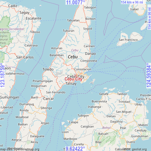
Cebu City GPS coordinates[2]
10° 19' 0.192" North, 123° 53' 26.556" East
| Map corner | latitude | longitude |
|---|---|---|
| Upper-left | 11.0077°, | 123.18759° |
| Center: | 10.31672°, | 123.89071° |
| Lower-right: | 9.62422°, | 124.59384° |
| Map W x H: | 153.8×153.8 km | = 95.6×95.6mi |
| max Lat: | 20.78733° ⇑65% North |
| Cebu City: | 10.31672° |
| min Lat: | ⇓35% South 4.65442° |
| min Long | Cebu City | max Long |
| 117.04868° | 123.89071° | 126.58417° |
| W 69.2%⇐ | ⇒30.8% E |
Elevation
Elevation of Cebu City is 37 m = 121 ft, and this is 50.9 m = 167 ft below average elevation for this country.
| Max E: |
2262 m = 7421 ft | 37.8% |
| Avg. | 87.9 m = 288 ft | |
| Cebu City | 37 m = 121 ft | |
Min E: |
-2 m = -7 ft | 62.2% |
See also: Cebu City elevation on elevation.city.
Geographical zone
Cebu City is located in North Torrid zone (between Equator and Tropic of Cancer). Distance of Equator is 1147.1 km =712.8 mi to South.| Distance of | km | miles | from Cebu City |
|---|---|---|---|
| North Pole | 8860 | 5505.3 | to North |
| Arctic Circle | 6254.1 | 3886.1 | to North |
| Tropic Cancer | 1458.8 | 906.5 | to North |
| Equator | 1147.1 | 712.8 | to South |


Nearby cities:
15 places around Cebu City: (largest is in red/bold)
• Adlaon
2.1 km =1.3 mi,  151°
151°
• Apas
3 km =1.9 mi,  25°
25°
• Baugo
3.1 km =1.9 mi,  88°
88°
• Buagsong
8.8 km =5.5 mi,  143°
143°
• Consolacion
9.9 km =6.2 mi,  47°
47°
• Cordova
9.9 km =6.2 mi, 145°
• Dapitan
8.8 km =5.5 mi,  133°
133°
• Gabi
9.8 km =6.1 mi, 127°
• Jaclupan
8.3 km =5.2 mi,  258°
258°
• Kuanos
12.7 km =7.9 mi,  252°
252°
• Lapu-Lapu City
6.5 km =4 mi,  96°
96°
• Mandaue City
3.5 km =2.2 mi,  77°
77°
• Minglanilla
13 km =8.1 mi,  232°
232°
• Talisay
9.2 km =5.7 mi,  209°
209°
• Tangke
7.5 km =4.7 mi,  202°
202°
Sources, notices
• [Note1] Compared only with cities in Philippines existing in our database
• [Src1] Map data: © OpenStreetMap contributors (CC-BY-SA)
• [Src2] Other city data from geonames.org with taken over terms of usage.
• [Src3] Geographical zone / Annual Mean Temperature by Robert A. Rohde @ Wikipedia
