Baugo geodata
Baugo (Central Visayas) is a populated place; located in Philippines in Asia/Manila (GMT+8) time zone. With population of 2,261 people, there are 3763 cities with bigger population in this country. Compared to other cities in Philippines, 64.9% of cities are located further ↑North; 69.6% of cities are located further ←West and 70.2% of cities have higher elevation than Baugo. Note1


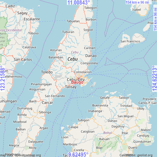
Baugo GPS coordinates[2]
10° 19' 2.82" North, 123° 55' 8.4" East
| Map corner | latitude | longitude |
|---|---|---|
| Upper-left | 11.00843°, | 123.21588° |
| Center: | 10.31745°, | 123.919° |
| Lower-right: | 9.62495°, | 124.62213° |
| Map W x H: | 153.8×153.8 km | = 95.6×95.6mi |
| max Lat: | 20.78733° ⇑64.9% North |
| Baugo: | 10.31745° |
| min Lat: | ⇓35.1% South 4.65442° |
| min Long | Baugo | max Long |
| 117.04868° | 123.919° | 126.58417° |
| W 69.6%⇐ | ⇒30.4% E |
Elevation
Elevation of Baugo is 12 m = 39 ft, and this is 75.9 m = 249 ft below average elevation for this country.
| Max E: |
2262 m = 7421 ft | 70.2% |
| Avg. | 87.9 m = 288 ft | |
| Baugo | 12 m = 39 ft | |
Min E: |
-2 m = -7 ft | 29.8% |
See also: Philippines elevation on elevation.city.
Geographical zone
Baugo is located in North Torrid zone (between Equator and Tropic of Cancer). Distance of Equator is 1147.2 km =712.8 mi to South.| Distance of | km | miles | from Baugo |
|---|---|---|---|
| North Pole | 8859.9 | 5505.3 | to North |
| Arctic Circle | 6254 | 3886.1 | to North |
| Tropic Cancer | 1458.7 | 906.4 | to North |
| Equator | 1147.2 | 712.8 | to South |


Nearby cities:
15 places around Baugo: (largest is in red/bold)
• Adlaon
2.8 km =1.7 mi,  226°
226°
• Apas
3.2 km =2 mi,  325°
325°
• Buagsong
7.5 km =4.7 mi,  162°
162°
• Calero
10.6 km =6.6 mi,  54°
54°
• Cebu City
3.1 km =1.9 mi,  268°
268°
• Consolacion
7.8 km =4.8 mi,  32°
32°
• Cordova
8.6 km =5.3 mi, 162°
• Dapitan
7 km =4.3 mi,  151°
151°
• Gabi
7.6 km =4.7 mi,  142°
142°
• Jaclupan
11.4 km =7.1 mi,  260°
260°
• Lapu-Lapu City
3.4 km =2.1 mi,  103°
103°
• Mandaue City
0.8 km =0.5 mi, 27°
• Talisay
11.1 km =6.9 mi,  223°
223°
• Tangke
9.1 km =5.7 mi, 220°
• Tayud
11.7 km =7.3 mi, 53°
Sources, notices
• [Note1] Compared only with cities in Philippines existing in our database
• [Src1] Map data: © OpenStreetMap contributors (CC-BY-SA)
• [Src2] Other city data from geonames.org with taken over terms of usage.
• [Src3] Geographical zone / Annual Mean Temperature by Robert A. Rohde @ Wikipedia
