Cordova geodata
Cordova (Central Visayas) is a destroyed populated place; located in Philippines in Asia/Manila (GMT+8) time zone. With population of 29,289 people, there are 282 cities with bigger population in this country. Compared to other cities in Philippines, 65.9% of cities are located further ↑North; 69.9% of cities are located further ←West and 95.5% of cities have higher elevation than Cordova. Note1


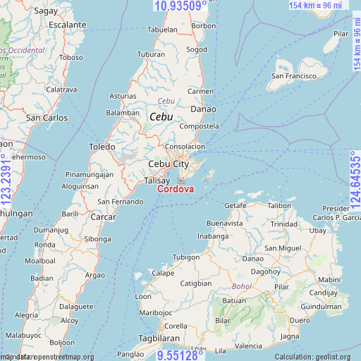
Cordova GPS coordinates[2]
10° 14' 38.184" North, 123° 56' 31.992" East
| Map corner | latitude | longitude |
|---|---|---|
| Upper-left | 10.93509°, | 123.2391° |
| Center: | 10.24394°, | 123.94222° |
| Lower-right: | 9.55128°, | 124.64535° |
| Map W x H: | 153.9×153.9 km | = 95.6×95.6mi |
| max Lat: | 20.78733° ⇑65.9% North |
| Cordova: | 10.24394° |
| min Lat: | ⇓34.1% South 4.65442° |
| min Long | Cordova | max Long |
| 117.04868° | 123.94222° | 126.58417° |
| W 69.9%⇐ | ⇒30.1% E |
Elevation
Elevation of Cordova is 5 m = 16 ft, and this is 82.9 m = 272 ft below average elevation for this country.
| Max E: |
2262 m = 7421 ft | 95.5% |
| Avg. | 87.9 m = 288 ft | |
| Cordova | 5 m = 16 ft | |
Min E: |
-2 m = -7 ft | 4.5% |
See also: Philippines elevation on elevation.city.
Geographical zone
Cordova is located in North Torrid zone (between Equator and Tropic of Cancer). Distance of Equator is 1139 km =707.7 mi to South.| Distance of | km | miles | from Cordova |
|---|---|---|---|
| North Pole | 8868 | 5510.3 | to North |
| Arctic Circle | 6262.2 | 3891.1 | to North |
| Tropic Cancer | 1466.9 | 911.5 | to North |
| Equator | 1139 | 707.7 | to South |


Nearby cities:
15 places around Cordova: (largest is in red/bold)
• Adlaon
7.8 km =4.8 mi,  323°
323°
• Apas
11.6 km =7.2 mi,  338°
338°
• Baugo
8.6 km =5.3 mi, 342°
• Buagsong
1.1 km =0.7 mi, 341°
• Cabul-an
14.8 km =9.2 mi,  131°
131°
• Calero
15.6 km =9.7 mi,  22°
22°
• Cebu City
9.9 km =6.2 mi,  325°
325°
• Consolacion
14.8 km =9.2 mi,  6°
6°
• Dapitan
2.2 km =1.4 mi, 21°
• Gabi
3 km =1.9 mi,  44°
44°
• Jaclupan
15.2 km =9.4 mi,  294°
294°
• Lapu-Lapu City
7.4 km =4.6 mi, 6°
• Mandaue City
9.1 km =5.7 mi,  346°
346°
• Talisay
10.2 km =6.3 mi,  270°
270°
• Tangke
8.5 km =5.3 mi,  277°
277°
Sources, notices
• [Note1] Compared only with cities in Philippines existing in our database
• [Src1] Map data: © OpenStreetMap contributors (CC-BY-SA)
• [Src2] Other city data from geonames.org with taken over terms of usage.
• [Src3] Geographical zone / Annual Mean Temperature by Robert A. Rohde @ Wikipedia
