Irahuan geodata
Irahuan (Mimaropa) is a populated place; located in Philippines in Asia/Manila (GMT+8) time zone. With population of 4,141 people, there are 1647 cities with bigger population in this country. Compared to other cities in Philippines, 70.2% of cities are located further ↑North; 99.2% of cities are located further →East and 65.1% of cities have higher elevation than Irahuan. Note1
Administrative division(s):
- Level 1: Mimaropa
- Level 2: Province of Palawan
- Level 3: Puerto Princesa City


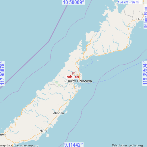
Irahuan GPS coordinates[2]
9° 48' 28.728" North, 118° 41' 30.876" East
| Map corner | latitude | longitude |
|---|---|---|
| Upper-left | 10.50009°, | 117.98879° |
| Center: | 9.80798°, | 118.69191° |
| Lower-right: | 9.11442°, | 119.39504° |
| Map W x H: | 154.1×154.1 km | = 95.8×95.8mi |
| max Lat: | 20.78733° ⇑70.2% North |
| Irahuan: | 9.80798° |
| min Lat: | ⇓29.8% South 4.65442° |
| min Long | Irahuan | max Long |
| 117.04868° | 118.69191° | 126.58417° |
| W 0.8%⇐ | ⇒99.2% E |
Elevation
Elevation of Irahuan is 14 m = 46 ft, and this is 73.9 m = 242 ft below average elevation for this country.
| Max E: |
2262 m = 7421 ft | 65.1% |
| Avg. | 87.9 m = 288 ft | |
| Irahuan | 14 m = 46 ft | |
Min E: |
-2 m = -7 ft | 34.9% |
See also: Philippines elevation on elevation.city.
Geographical zone
Irahuan is located in North Torrid zone (between Equator and Tropic of Cancer). Distance of Equator is 1090.5 km =677.6 mi to South.| Distance of | km | miles | from Irahuan |
|---|---|---|---|
| North Pole | 8916.5 | 5540.5 | to North |
| Arctic Circle | 6310.6 | 3921.2 | to North |
| Tropic Cancer | 1515.4 | 941.6 | to North |
| Equator | 1090.5 | 677.6 | to South |


Nearby cities:
15 places around Irahuan: (largest is in red/bold)
• Aborlan
44.5 km =27.7 mi,  200°
200°
• Apurawan
44.2 km =27.5 mi,  238°
238°
• Aramawayan
77.8 km =48.3 mi,  228°
228°
• Bacungan
11.5 km =7.1 mi,  5°
5°
• Baheli
24.5 km =15.2 mi,  21°
21°
• Calatugas
87.7 km =54.5 mi,  215°
215°
• Caramay
72.6 km =45.1 mi,  55°
55°
• Caruray
65.9 km =40.9 mi,  32°
32°
• Isugod
81.5 km =50.6 mi, 230°
• Narra
67.7 km =42.1 mi,  207°
207°
• Panacan
69.8 km =43.4 mi, 206°
• Plaridel
52.1 km =32.4 mi, 203°
• Puerto Princesa
9 km =5.6 mi,  148°
148°
• San Jose
7.2 km =4.5 mi,  96°
96°
• Tagburos
4.9 km =3 mi, 62°
Sources, notices
• [Note1] Compared only with cities in Philippines existing in our database
• [Src1] Map data: © OpenStreetMap contributors (CC-BY-SA)
• [Src2] Other city data from geonames.org with taken over terms of usage.
• [Src3] Geographical zone / Annual Mean Temperature by Robert A. Rohde @ Wikipedia
