Tagburos geodata
Tagburos (Mimaropa) is a populated place; located in Philippines in Asia/Manila (GMT+8) time zone. With population of 4,149 people, there are 1643 cities with bigger population in this country. Compared to other cities in Philippines, 70% of cities are located further ↑North; 99.2% of cities are located further →East and 69.6% of cities have lower elevation than Tagburos. Note1
Administrative division(s):
- Level 1: Mimaropa
- Level 2: Province of Palawan
- Level 3: Puerto Princesa City


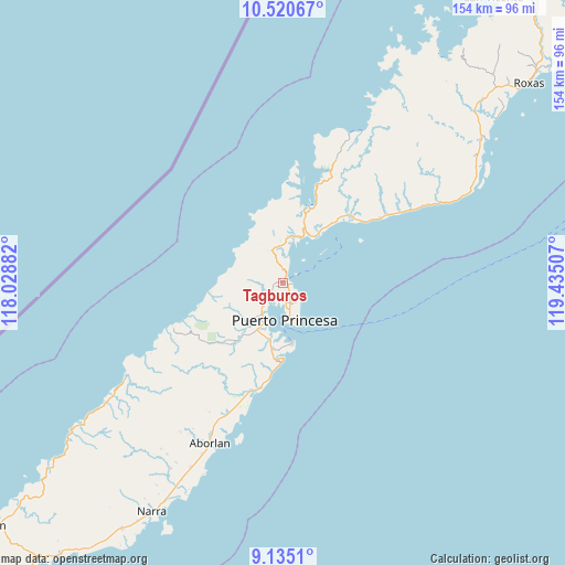
Tagburos GPS coordinates[2]
9° 49' 42.996" North, 118° 43' 54.984" East
| Map corner | latitude | longitude |
|---|---|---|
| Upper-left | 10.52067°, | 118.02882° |
| Center: | 9.82861°, | 118.73194° |
| Lower-right: | 9.1351°, | 119.43507° |
| Map W x H: | 154.1×154.1 km | = 95.8×95.8mi |
| max Lat: | 20.78733° ⇑70% North |
| Tagburos: | 9.82861° |
| min Lat: | ⇓30% South 4.65442° |
| min Long | Tagburos | max Long |
| 117.04868° | 118.73194° | 126.58417° |
| W 0.8%⇐ | ⇒99.2% E |
Elevation
Elevation of Tagburos is 51 m = 167 ft, and this is 36.9 m = 121 ft below average elevation for this country.
| Max E: |
2262 m = 7421 ft | 30.4% |
| Avg. | 87.9 m = 288 ft | |
| Tagburos | 51 m = 167 ft | |
Min E: |
-2 m = -7 ft | 69.6% |
See also: Philippines elevation on elevation.city.
Geographical zone
Tagburos is located in North Torrid zone (between Equator and Tropic of Cancer). Distance of Equator is 1092.8 km =679 mi to South.| Distance of | km | miles | from Tagburos |
|---|---|---|---|
| North Pole | 8914.2 | 5539 | to North |
| Arctic Circle | 6308.3 | 3919.8 | to North |
| Tropic Cancer | 1513.1 | 940.2 | to North |
| Equator | 1092.8 | 679 | to South |


Nearby cities:
15 places around Tagburos: (largest is in red/bold)
• Aborlan
48.3 km =30 mi,  204°
204°
• Apurawan
49.1 km =30.5 mi,  238°
238°
• Aramawayan
82.6 km =51.3 mi,  229°
229°
• Bacungan
9.7 km =6 mi,  340°
340°
• Baheli
21.1 km =13.1 mi,  12°
12°
• Caramay
67.7 km =42.1 mi,  54°
54°
• Caruray
61.7 km =38.3 mi,  29°
29°
• Irahuan
4.9 km =3 mi, 242°
• Isugod
86.3 km =53.6 mi, 231°
• Narra
71.9 km =44.7 mi,  209°
209°
• Panacan
73.8 km =45.9 mi, 208°
• Plaridel
56 km =34.8 mi, 206°
• Puerto Princesa
10 km =6.2 mi,  177°
177°
• Roxas
86.7 km =53.9 mi, 50°
• San Jose
4.2 km =2.6 mi,  138°
138°
Sources, notices
• [Note1] Compared only with cities in Philippines existing in our database
• [Src1] Map data: © OpenStreetMap contributors (CC-BY-SA)
• [Src2] Other city data from geonames.org with taken over terms of usage.
• [Src3] Geographical zone / Annual Mean Temperature by Robert A. Rohde @ Wikipedia
