Baheli geodata
Baheli (Mimaropa) is a populated place; located in Philippines in Asia/Manila (GMT+8) time zone. With population of 2,255 people, there are 3777 cities with bigger population in this country. Compared to other cities in Philippines, 68.1% of cities are located further ↑North; 99.1% of cities are located further →East and 95.5% of cities have higher elevation than Baheli. Note1
Administrative division(s):
- Level 1: Mimaropa
- Level 2: Province of Palawan
- Level 3: Puerto Princesa City


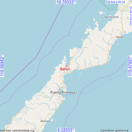
Baheli GPS coordinates[2]
10° 0' 49.284" North, 118° 46' 22.584" East
| Map corner | latitude | longitude |
|---|---|---|
| Upper-left | 10.70535°, | 118.06982° |
| Center: | 10.01369°, | 118.77294° |
| Lower-right: | 9.32055°, | 119.47607° |
| Map W x H: | 154×154 km | = 95.7×95.7mi |
| max Lat: | 20.78733° ⇑68.1% North |
| Baheli: | 10.01369° |
| min Lat: | ⇓31.9% South 4.65442° |
| min Long | Baheli | max Long |
| 117.04868° | 118.77294° | 126.58417° |
| W 0.9%⇐ | ⇒99.1% E |
Elevation
Elevation of Baheli is 5 m = 16 ft, and this is 82.9 m = 272 ft below average elevation for this country.
| Max E: |
2262 m = 7421 ft | 95.5% |
| Avg. | 87.9 m = 288 ft | |
| Baheli | 5 m = 16 ft | |
Min E: |
-2 m = -7 ft | 4.5% |
See also: Philippines elevation on elevation.city.
Geographical zone
Baheli is located in North Torrid zone (between Equator and Tropic of Cancer). Distance of Equator is 1113.4 km =691.8 mi to South.| Distance of | km | miles | from Baheli |
|---|---|---|---|
| North Pole | 8893.6 | 5526.2 | to North |
| Arctic Circle | 6287.8 | 3907.1 | to North |
| Tropic Cancer | 1492.5 | 927.4 | to North |
| Equator | 1113.4 | 691.8 | to South |


Nearby cities:
15 places around Baheli: (largest is in red/bold)
• Aborlan
69 km =42.9 mi,  200°
200°
• Apurawan
65.4 km =40.6 mi,  225°
225°
• Bacungan
13.8 km =8.6 mi,  214°
214°
• Caramay
54 km =33.6 mi,  69°
69°
• Caruray
42.1 km =26.2 mi,  38°
38°
• Irahuan
24.5 km =15.2 mi, 201°
• New Agutaya
84.5 km =52.5 mi, 43°
• Plaridel
76.6 km =47.6 mi, 202°
• Port Barton
73 km =45.4 mi,  45°
45°
• Puerto Princesa
30.8 km =19.1 mi,  187°
187°
• Roxas
71.4 km =44.4 mi,  61°
61°
• San Jose
23.8 km =14.8 mi,  184°
184°
• San Vicente
77.9 km =48.4 mi, 42°
• Tagburos
21.1 km =13.1 mi, 192°
• Tumarbong
85.1 km =52.9 mi, 61°
Sources, notices
• [Note1] Compared only with cities in Philippines existing in our database
• [Src1] Map data: © OpenStreetMap contributors (CC-BY-SA)
• [Src2] Other city data from geonames.org with taken over terms of usage.
• [Src3] Geographical zone / Annual Mean Temperature by Robert A. Rohde @ Wikipedia
