Capuluan geodata
Capuluan (Calabarzon) is a populated place; located in Philippines in Asia/Manila (GMT+8) time zone. With population of 2,234 people, there are 3813 cities with bigger population in this country. Compared to other cities in Philippines, 65.6% of cities are located further ↓South; 54.6% of cities are located further →East and 85.4% of cities have higher elevation than Capuluan. Note1


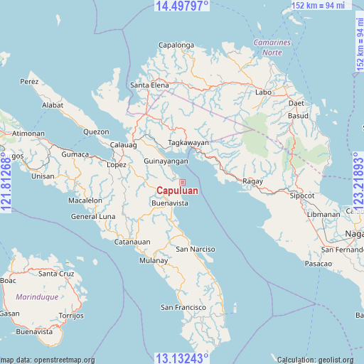
Capuluan GPS coordinates[2]
13° 48' 58.32" North, 122° 30' 56.88" East
| Map corner | latitude | longitude |
|---|---|---|
| Upper-left | 14.49797°, | 121.81268° |
| Center: | 13.8162°, | 122.5158° |
| Lower-right: | 13.13243°, | 123.21893° |
| Map W x H: | 151.8×151.8 km | = 94.3×94.3mi |
| max Lat: | 20.78733° ⇑34.4% North |
| Capuluan: | 13.8162° |
| min Lat: | ⇓65.6% South 4.65442° |
| min Long | Capuluan | max Long |
| 117.04868° | 122.5158° | 126.58417° |
| W 45.4%⇐ | ⇒54.6% E |
Elevation
Elevation of Capuluan is 8 m = 26 ft, and this is 79.9 m = 262 ft below average elevation for this country.
| Max E: |
2262 m = 7421 ft | 85.4% |
| Avg. | 87.9 m = 288 ft | |
| Capuluan | 8 m = 26 ft | |
Min E: |
-2 m = -7 ft | 14.6% |
See also: Philippines elevation on elevation.city.
Geographical zone
Capuluan is located in North Torrid zone (between Equator and Tropic of Cancer). Distance of this Northern Tropic circle is 1069.7 km =664.7 mi to North.| Distance of | km | miles | from Capuluan |
|---|---|---|---|
| North Pole | 8470.8 | 5263.5 | to North |
| Arctic Circle | 5865 | 3644.3 | to North |
| Tropic Cancer | 1069.7 | 664.7 | to North |
| Equator | 1536.2 | 954.6 | to South |


Nearby cities:
15 places around Capuluan: (largest is in red/bold)
• Abuyon
21.5 km =13.4 mi,  179°
179°
• Apad
27.1 km =16.8 mi,  90°
90°
• Cambuga
23.3 km =14.5 mi,  197°
197°
• Catabangan
17.2 km =10.7 mi,  66°
66°
• Del Gallego
14.6 km =9.1 mi,  36°
36°
• Guinayangan, Fourth District of Quezon
11.9 km =7.4 mi,  321°
321°
• Kinatakutan
16.3 km =10.1 mi,  341°
341°
• Lacdayan
24.1 km =15 mi, 175°
• Liboro
23.1 km =14.4 mi, 87°
• Mapulot
24.2 km =15 mi,  6°
6°
• Rosario
26.7 km =16.6 mi,  281°
281°
• San Francisco
24.8 km =15.4 mi,  263°
263°
• San Narciso
28.2 km =17.5 mi,  168°
168°
• Sinuknipan
15.5 km =9.6 mi,  58°
58°
• Tagkawayan Sabang
19.5 km =12.1 mi,  4°
4°
Sources, notices
• [Note1] Compared only with cities in Philippines existing in our database
• [Src1] Map data: © OpenStreetMap contributors (CC-BY-SA)
• [Src2] Other city data from geonames.org with taken over terms of usage.
• [Src3] Geographical zone / Annual Mean Temperature by Robert A. Rohde @ Wikipedia
