Del Gallego geodata
Del Gallego (Bicol) is a seat of a third-order administrative division; located in Philippines in Asia/Manila (GMT+8) time zone. With population of 4,070 people, there are 1679 cities with bigger population in this country. Compared to other cities in Philippines, 67.8% of cities are located further ↓South; 53% of cities are located further →East and 85.4% of cities have higher elevation than Del Gallego. Note1


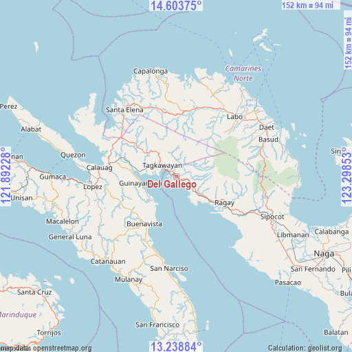
Del Gallego GPS coordinates[2]
13° 55' 20.28" North, 122° 35' 43.44" East
| Map corner | latitude | longitude |
|---|---|---|
| Upper-left | 14.60375°, | 121.89228° |
| Center: | 13.9223°, | 122.5954° |
| Lower-right: | 13.23884°, | 123.29853° |
| Map W x H: | 151.8×151.8 km | = 94.3×94.3mi |
| max Lat: | 20.78733° ⇑32.2% North |
| Del Gallego: | 13.9223° |
| min Lat: | ⇓67.8% South 4.65442° |
| min Long | Del Gallego | max Long |
| 117.04868° | 122.5954° | 126.58417° |
| W 47%⇐ | ⇒53% E |
Elevation
Elevation of Del Gallego is 8 m = 26 ft, and this is 79.9 m = 262 ft below average elevation for this country.
| Max E: |
2262 m = 7421 ft | 85.4% |
| Avg. | 87.9 m = 288 ft | |
| Del Gallego | 8 m = 26 ft | |
Min E: |
-2 m = -7 ft | 14.6% |
See also: Philippines elevation on elevation.city.
Geographical zone
Del Gallego is located in North Torrid zone (between Equator and Tropic of Cancer). Distance of this Northern Tropic circle is 1057.9 km =657.3 mi to North.| Distance of | km | miles | from Del Gallego |
|---|---|---|---|
| North Pole | 8459 | 5256.2 | to North |
| Arctic Circle | 5853.2 | 3637 | to North |
| Tropic Cancer | 1057.9 | 657.3 | to North |
| Equator | 1548 | 961.9 | to South |


Nearby cities:
15 places around Del Gallego: (largest is in red/bold)
• Apad
22 km =13.7 mi,  122°
122°
• Capuluan
14.6 km =9.1 mi,  216°
216°
• Catabangan
8.7 km =5.4 mi, 124°
• Daguit
32.9 km =20.4 mi,  25°
25°
• Guinayangan, Fourth District of Quezon
16.1 km =10 mi,  261°
261°
• Kinatakutan
14.2 km =8.8 mi,  284°
284°
• Liboro
18.1 km =11.2 mi,  126°
126°
• Lugui
30.1 km =18.7 mi,  45°
45°
• Malatap
30.8 km =19.1 mi,  342°
342°
• Mapulot
13.7 km =8.5 mi,  334°
334°
• Ragay
24.2 km =15 mi, 118°
• Sinuknipan
5.8 km =3.6 mi, 128°
• Tagkawayan Sabang
10.4 km =6.5 mi,  317°
317°
• Tigbinan
32.4 km =20.1 mi, 335°
• Tulay na Lupa
28 km =17.4 mi, 47°
Sources, notices
• [Note1] Compared only with cities in Philippines existing in our database
• [Src1] Map data: © OpenStreetMap contributors (CC-BY-SA)
• [Src2] Other city data from geonames.org with taken over terms of usage.
• [Src3] Geographical zone / Annual Mean Temperature by Robert A. Rohde @ Wikipedia
