Sinuknipan geodata
Sinuknipan (Bicol) is a populated place; located in Philippines in Asia/Manila (GMT+8) time zone. With population of 2,533 people, there are 3238 cities with bigger population in this country. Compared to other cities in Philippines, 67.3% of cities are located further ↓South; 52.4% of cities are located further →East and 74.1% of cities have lower elevation than Sinuknipan. Note1


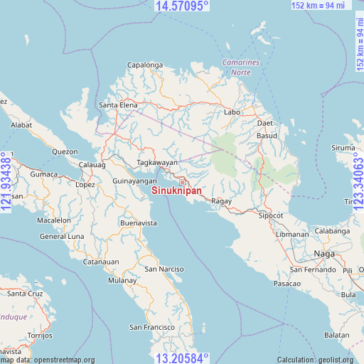
Sinuknipan GPS coordinates[2]
13° 53' 21.84" North, 122° 38' 15" East
| Map corner | latitude | longitude |
|---|---|---|
| Upper-left | 14.57095°, | 121.93438° |
| Center: | 13.8894°, | 122.6375° |
| Lower-right: | 13.20584°, | 123.34063° |
| Map W x H: | 151.8×151.8 km | = 94.3×94.3mi |
| max Lat: | 20.78733° ⇑32.7% North |
| Sinuknipan: | 13.8894° |
| min Lat: | ⇓67.3% South 4.65442° |
| min Long | Sinuknipan | max Long |
| 117.04868° | 122.6375° | 126.58417° |
| W 47.6%⇐ | ⇒52.4% E |
Elevation
Elevation of Sinuknipan is 65 m = 213 ft, and this is 22.9 m = 75 ft below average elevation for this country.
| Max E: |
2262 m = 7421 ft | 25.9% |
| Avg. | 87.9 m = 288 ft | |
| Sinuknipan | 65 m = 213 ft | |
Min E: |
-2 m = -7 ft | 74.1% |
See also: Philippines elevation on elevation.city.
Geographical zone
Sinuknipan is located in North Torrid zone (between Equator and Tropic of Cancer). Distance of this Northern Tropic circle is 1061.6 km =659.6 mi to North.| Distance of | km | miles | from Sinuknipan |
|---|---|---|---|
| North Pole | 8462.7 | 5258.5 | to North |
| Arctic Circle | 5856.8 | 3639.2 | to North |
| Tropic Cancer | 1061.6 | 659.6 | to North |
| Equator | 1544.4 | 959.6 | to South |


Nearby cities:
15 places around Sinuknipan: (largest is in red/bold)
• Apad
16.2 km =10.1 mi,  120°
120°
• Capuluan
15.5 km =9.6 mi,  238°
238°
• Catabangan
2.9 km =1.8 mi, 116°
• Culacling
28.5 km =17.7 mi,  114°
114°
• Del Gallego
5.8 km =3.6 mi,  308°
308°
• Guinayangan, Fourth District of Quezon
20.5 km =12.7 mi,  273°
273°
• Imelda
31 km =19.3 mi,  58°
58°
• Kinatakutan
19.7 km =12.2 mi,  291°
291°
• Liboro
12.3 km =7.6 mi,  126°
126°
• Lugui
30 km =18.6 mi,  34°
34°
• Lupi Viejo
31.4 km =19.5 mi, 110°
• Mapulot
19.1 km =11.9 mi,  326°
326°
• Ragay
18.5 km =11.5 mi, 115°
• Tagkawayan Sabang
16.2 km =10.1 mi, 314°
• Tulay na Lupa
27.8 km =17.3 mi,  35°
35°
Sources, notices
• [Note1] Compared only with cities in Philippines existing in our database
• [Src1] Map data: © OpenStreetMap contributors (CC-BY-SA)
• [Src2] Other city data from geonames.org with taken over terms of usage.
• [Src3] Geographical zone / Annual Mean Temperature by Robert A. Rohde @ Wikipedia
