Bulaon geodata
Bulaon (Central Luzon) is a populated place; located in Philippines in Asia/Manila (GMT+8) time zone. With population of 131,818 people, there are 74 cities with bigger population in this country. Compared to other cities in Philippines, 78.4% of cities are located further ↓South; 86% of cities are located further →East and 58.1% of cities have lower elevation than Bulaon. Note1
Administrative division(s):
- Level 1: Central Luzon
- Level 2: Province of Pampanga
- Level 3: City of San Fernando


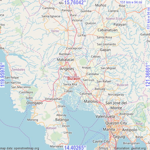
Bulaon GPS coordinates[2]
15° 4' 57.432" North, 120° 39' 46.368" East
| Map corner | latitude | longitude |
|---|---|---|
| Upper-left | 15.76042°, | 119.95976° |
| Center: | 15.08262°, | 120.66288° |
| Lower-right: | 14.40265°, | 121.36601° |
| Map W x H: | 151×151 km | = 93.8×93.8mi |
| max Lat: | 20.78733° ⇑21.6% North |
| Bulaon: | 15.08262° |
| min Lat: | ⇓78.4% South 4.65442° |
| min Long | Bulaon | max Long |
| 117.04868° | 120.66288° | 126.58417° |
| W 14%⇐ | ⇒86% E |
Elevation
Elevation of Bulaon is 31 m = 102 ft, and this is 56.9 m = 187 ft below average elevation for this country.
| Max E: |
2262 m = 7421 ft | 41.9% |
| Avg. | 87.9 m = 288 ft | |
| Bulaon | 31 m = 102 ft | |
Min E: |
-2 m = -7 ft | 58.1% |
See also: Bulaon elevation on elevation.city.
Geographical zone
Bulaon is located in North Torrid zone (between Equator and Tropic of Cancer). Distance of this Northern Tropic circle is 928.9 km =577.2 mi to North.| Distance of | km | miles | from Bulaon |
|---|---|---|---|
| North Pole | 8330 | 5176 | to North |
| Arctic Circle | 5724.1 | 3556.8 | to North |
| Tropic Cancer | 928.9 | 577.2 | to North |
| Equator | 1677 | 1042 | to South |


Nearby cities:
15 places around Bulaon: (largest is in red/bold)
• Acli
4.9 km =3 mi,  336°
336°
• Anao
7.2 km =4.5 mi,  25°
25°
• Calibutbut
7.8 km =4.8 mi,  297°
297°
• Cauayan
7.7 km =4.8 mi,  7°
7°
• Culubasa
7 km =4.3 mi,  350°
350°
• Del Pilar
6.5 km =4 mi,  142°
142°
• Magliman
5.2 km =3.2 mi,  178°
178°
• Malino
5.1 km =3.2 mi, 13°
• Mexico
6.4 km =4 mi,  108°
108°
• Pau
9 km =5.6 mi,  132°
132°
• San Antonio
8.2 km =5.1 mi,  19°
19°
• San Fernando
5.9 km =3.7 mi,  156°
156°
• San Juan
6.8 km =4.2 mi,  166°
166°
• San Patricio
7.3 km =4.5 mi,  76°
76°
• Telabastagan
7.1 km =4.4 mi, 304°
Sources, notices
• [Note1] Compared only with cities in Philippines existing in our database
• [Src1] Map data: © OpenStreetMap contributors (CC-BY-SA)
• [Src2] Other city data from geonames.org with taken over terms of usage.
• [Src3] Geographical zone / Annual Mean Temperature by Robert A. Rohde @ Wikipedia
