Calabugao geodata
Calabugao (Northern Mindanao) is a populated place; located in Philippines in Asia/Manila (GMT+8) time zone. With population of 5,982 people, there are 1051 cities with bigger population in this country. Compared to other cities in Philippines, 79% of cities are located further ↑North; 89.8% of cities are located further ←West and 98.5% of cities have lower elevation than Calabugao. Note1
Administrative division(s):
- Level 1: Northern Mindanao
- Level 2: Province of Bukidnon
- Level 3: Impasug-Ong


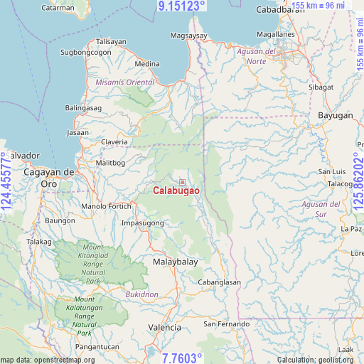
Calabugao GPS coordinates[2]
8° 27' 23.004" North, 125° 9' 32.004" East
| Map corner | latitude | longitude |
|---|---|---|
| Upper-left | 9.15123°, | 124.45577° |
| Center: | 8.45639°, | 125.15889° |
| Lower-right: | 7.7603°, | 125.86202° |
| Map W x H: | 154.7×154.7 km | = 96.1×96.1mi |
| max Lat: | 20.78733° ⇑79% North |
| Calabugao: | 8.45639° |
| min Lat: | ⇓21% South 4.65442° |
| min Long | Calabugao | max Long |
| 117.04868° | 125.15889° | 126.58417° |
| W 89.8%⇐ | ⇒10.2% E |
Elevation
Elevation of Calabugao is 833 m = 2733 ft, and this is 745.1 m = 2445 ft above average elevation for this country.
| Max E: |
2262 m = 7421 ft | 1.5% |
| Calabugao | 833 m 2733 ft | |
| Avg. | 87.9 m = 288 ft | |
Min E: |
-2 m = -7 ft | 98.5% |
See also: Philippines elevation on elevation.city.
Geographical zone
Calabugao is located in North Torrid zone (between Equator and Tropic of Cancer). Distance of Equator is 940.3 km =584.3 mi to South.| Distance of | km | miles | from Calabugao |
|---|---|---|---|
| North Pole | 9066.8 | 5633.8 | to North |
| Arctic Circle | 6460.9 | 4014.6 | to North |
| Tropic Cancer | 1665.7 | 1035 | to North |
| Equator | 940.3 | 584.3 | to South |


Nearby cities:
15 places around Calabugao: (largest is in red/bold)
• Busdi
22.5 km =14 mi,  153°
153°
• Canayan
29 km =18 mi,  183°
183°
• Claveria
33.7 km =20.9 mi,  300°
300°
• Dalirig
29.7 km =18.5 mi,  252°
252°
• Dalwangan
31.3 km =19.4 mi,  204°
204°
• Dumalaguing
16.7 km =10.4 mi,  223°
223°
• Impalutao
26.4 km =16.4 mi,  213°
213°
• Kisolon
24.5 km =15.2 mi,  234°
234°
• La Fortuna
26.2 km =16.3 mi, 221°
• Malaybalay
33.4 km =20.8 mi,  185°
185°
• Malitbog
31.5 km =19.6 mi,  285°
285°
• Maluko
24.3 km =15.1 mi, 248°
• San Luis
17.7 km =11 mi,  279°
279°
• Sumilao
30.1 km =18.7 mi, 231°
• Sumpong
32.9 km =20.4 mi, 187°
Sources, notices
• [Note1] Compared only with cities in Philippines existing in our database
• [Src1] Map data: © OpenStreetMap contributors (CC-BY-SA)
• [Src2] Other city data from geonames.org with taken over terms of usage.
• [Src3] Geographical zone / Annual Mean Temperature by Robert A. Rohde @ Wikipedia
