Busdi geodata
Busdi (Northern Mindanao) is a populated place; located in Philippines in Asia/Manila (GMT+8) time zone. With population of 2,168 people, there are 3955 cities with bigger population in this country. Compared to other cities in Philippines, 80.2% of cities are located further ↑North; 90.8% of cities are located further ←West and 97.2% of cities have lower elevation than Busdi. Note1
Administrative division(s):
- Level 1: Northern Mindanao
- Level 2: Province of Bukidnon
- Level 3: City of Malaybalay


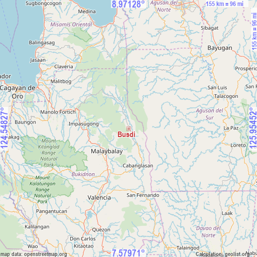
Busdi GPS coordinates[2]
8° 16' 33.996" North, 125° 15' 5.004" East
| Map corner | latitude | longitude |
|---|---|---|
| Upper-left | 8.97128°, | 124.54827° |
| Center: | 8.27611°, | 125.25139° |
| Lower-right: | 7.57971°, | 125.95452° |
| Map W x H: | 154.7×154.7 km | = 96.1×96.1mi |
| max Lat: | 20.78733° ⇑80.2% North |
| Busdi: | 8.27611° |
| min Lat: | ⇓19.8% South 4.65442° |
| min Long | Busdi | max Long |
| 117.04868° | 125.25139° | 126.58417° |
| W 90.8%⇐ | ⇒9.2% E |
Elevation
Elevation of Busdi is 632 m = 2073 ft, and this is 544.1 m = 1785 ft above average elevation for this country.
| Max E: |
2262 m = 7421 ft | 2.8% |
| Busdi | 632 m 2073 ft | |
| Avg. | 87.9 m = 288 ft | |
Min E: |
-2 m = -7 ft | 97.2% |
See also: Philippines elevation on elevation.city.
Geographical zone
Busdi is located in North Torrid zone (between Equator and Tropic of Cancer). Distance of Equator is 920.2 km =571.8 mi to South.| Distance of | km | miles | from Busdi |
|---|---|---|---|
| North Pole | 9086.8 | 5646.3 | to North |
| Arctic Circle | 6481 | 4027.1 | to North |
| Tropic Cancer | 1685.7 | 1047.4 | to North |
| Equator | 920.2 | 571.8 | to South |


Nearby cities:
15 places around Busdi: (largest is in red/bold)
• Cabanglasan
19.1 km =11.9 mi,  154°
154°
• Calabugao
22.5 km =14 mi,  333°
333°
• Canayan
14.8 km =9.2 mi,  232°
232°
• Casisang
20.7 km =12.9 mi,  222°
222°
• Dalwangan
24.7 km =15.3 mi,  250°
250°
• Dumalaguing
23 km =14.3 mi,  290°
290°
• Imbatug
24.9 km =15.5 mi,  171°
171°
• Impalutao
24.7 km =15.3 mi,  265°
265°
• Kabulohan
26 km =16.2 mi, 173°
• Laguitas
24.7 km =15.3 mi,  212°
212°
• Linabo
26.9 km =16.7 mi,  203°
203°
• Maglamin
25 km =15.5 mi,  177°
177°
• Malaybalay
18.9 km =11.7 mi, 225°
• Silae
13.5 km =8.4 mi, 165°
• Sumpong
19.3 km =12 mi, 229°
Sources, notices
• [Note1] Compared only with cities in Philippines existing in our database
• [Src1] Map data: © OpenStreetMap contributors (CC-BY-SA)
• [Src2] Other city data from geonames.org with taken over terms of usage.
• [Src3] Geographical zone / Annual Mean Temperature by Robert A. Rohde @ Wikipedia
