Cabusao geodata
Cabusao (Bicol) is a seat of a third-order administrative division; located in Philippines in Asia/Manila (GMT+8) time zone. With population of 2,269 people, there are 3745 cities with bigger population in this country. Compared to other cities in Philippines, 64.6% of cities are located further ↓South; 55.3% of cities are located further ←West and 98.1% of cities have higher elevation than Cabusao. Note1


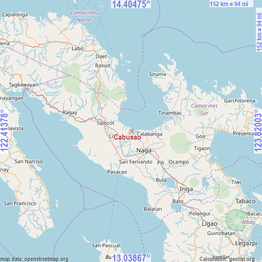
Cabusao GPS coordinates[2]
13° 43' 21.72" North, 123° 7' 0.84" East
| Map corner | latitude | longitude |
|---|---|---|
| Upper-left | 14.40475°, | 122.41378° |
| Center: | 13.7227°, | 123.1169° |
| Lower-right: | 13.03867°, | 123.82003° |
| Map W x H: | 151.9×151.9 km | = 94.4×94.4mi |
| max Lat: | 20.78733° ⇑35.4% North |
| Cabusao: | 13.7227° |
| min Lat: | ⇓64.6% South 4.65442° |
| min Long | Cabusao | max Long |
| 117.04868° | 123.1169° | 126.58417° |
| W 55.3%⇐ | ⇒44.7% E |
Elevation
Elevation of Cabusao is 3 m = 10 ft, and this is 84.9 m = 279 ft below average elevation for this country.
| Max E: |
2262 m = 7421 ft | 98.1% |
| Avg. | 87.9 m = 288 ft | |
| Cabusao | 3 m = 10 ft | |
Min E: |
-2 m = -7 ft | 1.9% |
See also: Philippines elevation on elevation.city.
Geographical zone
Cabusao is located in North Torrid zone (between Equator and Tropic of Cancer). Distance of this Northern Tropic circle is 1080.1 km =671.1 mi to North.| Distance of | km | miles | from Cabusao |
|---|---|---|---|
| North Pole | 8481.2 | 5270 | to North |
| Arctic Circle | 5875.4 | 3650.8 | to North |
| Tropic Cancer | 1080.1 | 671.1 | to North |
| Equator | 1525.8 | 948.1 | to South |


Nearby cities:
15 places around Cabusao: (largest is in red/bold)
• Barcelona
9.2 km =5.7 mi,  306°
306°
• Bombon
10.5 km =6.5 mi,  111°
111°
• Calabanga
10.1 km =6.3 mi,  100°
100°
• Canaman
10.1 km =6.3 mi,  145°
145°
• Castillo
1 km =0.6 mi,  358°
358°
• Dugcal
12 km =7.5 mi,  156°
156°
• Gainza
12.1 km =7.5 mi,  167°
167°
• Libmanan
7 km =4.3 mi,  241°
241°
• Magarao
10.3 km =6.4 mi,  132°
132°
• Mambulo
7.3 km =4.5 mi,  264°
264°
• Marupit
11.9 km =7.4 mi, 153°
• Pandan
4.4 km =2.7 mi,  299°
299°
• San Lucas
9.5 km =5.9 mi, 101°
• San Vicente
9.3 km =5.8 mi, 105°
• Santo Domingo
5.9 km =3.7 mi,  115°
115°
Sources, notices
• [Note1] Compared only with cities in Philippines existing in our database
• [Src1] Map data: © OpenStreetMap contributors (CC-BY-SA)
• [Src2] Other city data from geonames.org with taken over terms of usage.
• [Src3] Geographical zone / Annual Mean Temperature by Robert A. Rohde @ Wikipedia
