Bincoñgan geodata
Bincoñgan (Davao) is a populated place; located in Philippines in Asia/Manila (GMT+8) time zone. With population of 3,810 people, there are 1836 cities with bigger population in this country. Compared to other cities in Philippines, 88% of cities are located further ↑North; 96.2% of cities are located further ←West and 70.2% of cities have higher elevation than Bincoñgan. Note1
Administrative division(s):
- Level 1: Davao
- Level 2: Province of Davao del Norte
- Level 3: City of Tagum


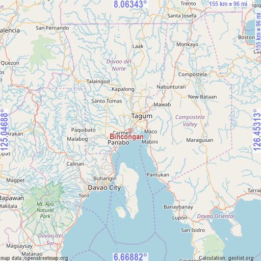
Bincoñgan GPS coordinates[2]
7° 22' 0.012" North, 125° 45' 0" East
| Map corner | latitude | longitude |
|---|---|---|
| Upper-left | 8.06343°, | 125.04688° |
| Center: | 7.36667°, | 125.75° |
| Lower-right: | 6.66882°, | 126.45313° |
| Map W x H: | 155.1×155.1 km | = 96.4×96.4mi |
| max Lat: | 20.78733° ⇑88% North |
| Bincoñgan: | 7.36667° |
| min Lat: | ⇓12% South 4.65442° |
| min Long | Bincoñgan | max Long |
| 117.04868° | 125.75° | 126.58417° |
| W 96.2%⇐ | ⇒3.8% E |
Elevation
Elevation of Bincoñgan is 12 m = 39 ft, and this is 75.9 m = 249 ft below average elevation for this country.
| Max E: |
2262 m = 7421 ft | 70.2% |
| Avg. | 87.9 m = 288 ft | |
| Bincoñgan | 12 m = 39 ft | |
Min E: |
-2 m = -7 ft | 29.8% |
See also: Philippines elevation on elevation.city.
Geographical zone
Bincoñgan is located in North Torrid zone (between Equator and Tropic of Cancer). Distance of Equator is 819.1 km =509 mi to South.| Distance of | km | miles | from Bincoñgan |
|---|---|---|---|
| North Pole | 9188 | 5709.2 | to North |
| Arctic Circle | 6582.1 | 4089.9 | to North |
| Tropic Cancer | 1786.8 | 1110.3 | to North |
| Equator | 819.1 | 509 | to South |


Nearby cities:
15 places around Bincoñgan: (largest is in red/bold)
• Alejal
10.1 km =6.3 mi,  281°
281°
• Anibongan
4.5 km =2.8 mi,  310°
310°
• Cabayangan
4.9 km =3 mi,  337°
337°
• Carmen
4.9 km =3 mi,  261°
261°
• Corocotan
4.5 km =2.8 mi,  34°
34°
• Hiju, Maco
8.9 km =5.5 mi,  76°
76°
• La Paz
5.9 km =3.7 mi,  198°
198°
• Libuganon
3.7 km =2.3 mi,  122°
122°
• Maco
11.6 km =7.2 mi,  92°
92°
• Magugpo Poblacion
10.8 km =6.7 mi, 33°
• Manaloal
9.9 km =6.2 mi,  269°
269°
• Panabo
9.8 km =6.1 mi,  228°
228°
• Santo Niño
6.6 km =4.1 mi, 228°
• Tubod
11.6 km =7.2 mi, 272°
• Tuganay
3 km =1.9 mi, 274°
Sources, notices
• [Note1] Compared only with cities in Philippines existing in our database
• [Src1] Map data: © OpenStreetMap contributors (CC-BY-SA)
• [Src2] Other city data from geonames.org with taken over terms of usage.
• [Src3] Geographical zone / Annual Mean Temperature by Robert A. Rohde @ Wikipedia
