Batuan geodata
Batuan (Central Visayas) is a seat of a third-order administrative division; located in Philippines in Asia/Manila (GMT+8) time zone. With population of 4,053 people, there are 1697 cities with bigger population in this country. Compared to other cities in Philippines, 70.7% of cities are located further ↑North; 73.4% of cities are located further ←West and 92.5% of cities have lower elevation than Batuan. Note1


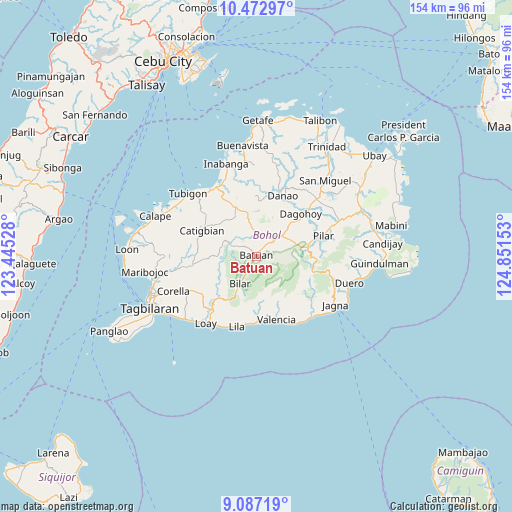
Batuan GPS coordinates[2]
9° 46' 50.88" North, 124° 8' 54.24" East
| Map corner | latitude | longitude |
|---|---|---|
| Upper-left | 10.47297°, | 123.44528° |
| Center: | 9.7808°, | 124.1484° |
| Lower-right: | 9.08719°, | 124.85153° |
| Map W x H: | 154.1×154.1 km | = 95.8×95.8mi |
| max Lat: | 20.78733° ⇑70.7% North |
| Batuan: | 9.7808° |
| min Lat: | ⇓29.3% South 4.65442° |
| min Long | Batuan | max Long |
| 117.04868° | 124.1484° | 126.58417° |
| W 73.4%⇐ | ⇒26.6% E |
Elevation
Elevation of Batuan is 306 m = 1004 ft, and this is 218.1 m = 716 ft above average elevation for this country.
| Max E: |
2262 m = 7421 ft | 7.5% |
| Batuan | 306 m 1004 ft | |
| Avg. | 87.9 m = 288 ft | |
Min E: |
-2 m = -7 ft | 92.5% |
See also: Philippines elevation on elevation.city.
Geographical zone
Batuan is located in North Torrid zone (between Equator and Tropic of Cancer). Distance of Equator is 1087.5 km =675.7 mi to South.| Distance of | km | miles | from Batuan |
|---|---|---|---|
| North Pole | 8919.5 | 5542.3 | to North |
| Arctic Circle | 6313.7 | 3923.2 | to North |
| Tropic Cancer | 1518.4 | 943.5 | to North |
| Equator | 1087.5 | 675.7 | to South |


Nearby cities:
15 places around Batuan: (largest is in red/bold)
• Bilar
9.2 km =5.7 mi,  209°
209°
• Buenavista
10.5 km =6.5 mi,  50°
50°
• Bugsoc
13.5 km =8.4 mi,  88°
88°
• Canmaya Diot
18.5 km =11.5 mi,  341°
341°
• Carmen
7 km =4.3 mi, 48°
• Catigbian
18.1 km =11.2 mi,  295°
295°
• Danao
17.3 km =10.7 mi,  160°
160°
• Estaca
16.7 km =10.4 mi,  125°
125°
• Nueva Fuerza
7.6 km =4.7 mi,  15°
15°
• Nueva Vida Sur
2.9 km =1.8 mi,  81°
81°
• Sagbayan
16.1 km =10 mi, 337°
• San Isidro
11.5 km =7.1 mi,  95°
95°
• Sevilla
13.9 km =8.6 mi,  232°
232°
• Sierra Bullones
16 km =9.9 mi, 79°
• Valle Hermoso
9.8 km =6.1 mi, 81°
Sources, notices
• [Note1] Compared only with cities in Philippines existing in our database
• [Src1] Map data: © OpenStreetMap contributors (CC-BY-SA)
• [Src2] Other city data from geonames.org with taken over terms of usage.
• [Src3] Geographical zone / Annual Mean Temperature by Robert A. Rohde @ Wikipedia
