Bonga geodata
Bonga (Bicol) is a populated place; located in Philippines in Asia/Manila (GMT+8) time zone. With population of 6,566 people, there are 955 cities with bigger population in this country. Compared to other cities in Philippines, 59.8% of cities are located further ↓South; 67.1% of cities are located further ←West and 86.7% of cities have lower elevation than Bonga. Note1


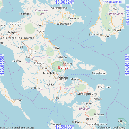
Bonga GPS coordinates[2]
13° 16' 47.64" North, 123° 45' 31.32" East
| Map corner | latitude | longitude |
|---|---|---|
| Upper-left | 13.96324°, | 123.05558° |
| Center: | 13.2799°, | 123.7587° |
| Lower-right: | 12.59463°, | 124.46183° |
| Map W x H: | 152.2×152.2 km | = 94.6×94.6mi |
| max Lat: | 20.78733° ⇑40.2% North |
| Bonga: | 13.2799° |
| min Lat: | ⇓59.8% South 4.65442° |
| min Long | Bonga | max Long |
| 117.04868° | 123.7587° | 126.58417° |
| W 67.1%⇐ | ⇒32.9% E |
Elevation
Elevation of Bonga is 160 m = 525 ft, and this is 72.1 m = 237 ft above average elevation for this country.
| Max E: |
2262 m = 7421 ft | 13.3% |
| Bonga | 160 m 525 ft | |
| Avg. | 87.9 m = 288 ft | |
Min E: |
-2 m = -7 ft | 86.7% |
See also: Philippines elevation on elevation.city.
Geographical zone
Bonga is located in North Torrid zone (between Equator and Tropic of Cancer). Distance of this Northern Tropic circle is 1129.3 km =701.7 mi to North.| Distance of | km | miles | from Bonga |
|---|---|---|---|
| North Pole | 8530.5 | 5300.6 | to North |
| Arctic Circle | 5924.6 | 3681.4 | to North |
| Tropic Cancer | 1129.3 | 701.7 | to North |
| Equator | 1476.6 | 917.5 | to South |


Nearby cities:
15 places around Bonga: (largest is in red/bold)
• Anuling
11.9 km =7.4 mi,  228°
228°
• Bacacay
3.9 km =2.4 mi,  67°
67°
• Bigaa
9 km =5.6 mi,  181°
181°
• Binitayan
1.6 km =1 mi,  356°
356°
• Libog
5.4 km =3.4 mi,  157°
157°
• Malilipot
4.8 km =3 mi,  333°
333°
• Miliroc
9.5 km =5.9 mi,  319°
319°
• Padang
6.7 km =4.2 mi,  173°
173°
• Pawa
11.8 km =7.3 mi,  195°
195°
• San Andres
3 km =1.9 mi,  132°
132°
• San Francisco
4.2 km =2.6 mi,  347°
347°
• San Roque
1.8 km =1.1 mi,  283°
283°
• Santo Domingo
5.4 km =3.4 mi, 158°
• Sugcad
11.6 km =7.2 mi, 326°
• Tabaco
9.2 km =5.7 mi,  342°
342°
Sources, notices
• [Note1] Compared only with cities in Philippines existing in our database
• [Src1] Map data: © OpenStreetMap contributors (CC-BY-SA)
• [Src2] Other city data from geonames.org with taken over terms of usage.
• [Src3] Geographical zone / Annual Mean Temperature by Robert A. Rohde @ Wikipedia
