Tabaco geodata
Tabaco (Bicol) is a seat of a third-order administrative division; located in Philippines in Asia/Manila (GMT+8) time zone. With population of 57,860 people, there are 161 cities with bigger population in this country. Compared to other cities in Philippines, 60.7% of cities are located further ↓South; 66.4% of cities are located further ←West and 97.1% of cities have higher elevation than Tabaco. Note1


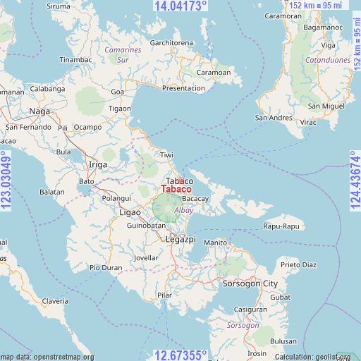
Tabaco GPS coordinates[2]
13° 21' 30.996" North, 123° 44' 0.996" East
| Map corner | latitude | longitude |
|---|---|---|
| Upper-left | 14.04173°, | 123.03049° |
| Center: | 13.35861°, | 123.73361° |
| Lower-right: | 12.67355°, | 124.43674° |
| Map W x H: | 152.1×152.1 km | = 94.5×94.5mi |
| max Lat: | 20.78733° ⇑39.3% North |
| Tabaco: | 13.35861° |
| min Lat: | ⇓60.7% South 4.65442° |
| min Long | Tabaco | max Long |
| 117.04868° | 123.73361° | 126.58417° |
| W 66.4%⇐ | ⇒33.6% E |
Elevation
Elevation of Tabaco is 4 m = 13 ft, and this is 83.9 m = 275 ft below average elevation for this country.
| Max E: |
2262 m = 7421 ft | 97.1% |
| Avg. | 87.9 m = 288 ft | |
| Tabaco | 4 m = 13 ft | |
Min E: |
-2 m = -7 ft | 2.9% |
See also: Tabaco elevation on elevation.city.
Geographical zone
Tabaco is located in North Torrid zone (between Equator and Tropic of Cancer). Distance of this Northern Tropic circle is 1120.6 km =696.3 mi to North.| Distance of | km | miles | from Tabaco |
|---|---|---|---|
| North Pole | 8521.7 | 5295.1 | to North |
| Arctic Circle | 5915.8 | 3675.9 | to North |
| Tropic Cancer | 1120.6 | 696.3 | to North |
| Equator | 1485.3 | 922.9 | to South |


Nearby cities:
15 places around Tabaco: (largest is in red/bold)
• Bacacay
9.6 km =6 mi,  138°
138°
• Balading
4.3 km =2.7 mi,  326°
326°
• Banag
4 km =2.5 mi,  304°
304°
• Baybay
5.9 km =3.7 mi,  338°
338°
• Binitayan
7.6 km =4.7 mi,  159°
159°
• Bonga
9.2 km =5.7 mi, 162°
• Estancia
5.8 km =3.6 mi,  270°
270°
• Labnig
6.3 km =3.9 mi,  288°
288°
• Malilipot
4.5 km =2.8 mi,  173°
173°
• Malinao
5.4 km =3.4 mi, 327°
• Miliroc
3.7 km =2.3 mi,  245°
245°
• San Francisco
5 km =3.1 mi, 159°
• San Roque
8.4 km =5.2 mi, 173°
• Sugcad
3.7 km =2.3 mi,  283°
283°
• Tagoytoy
8.8 km =5.5 mi,  316°
316°
Sources, notices
• [Note1] Compared only with cities in Philippines existing in our database
• [Src1] Map data: © OpenStreetMap contributors (CC-BY-SA)
• [Src2] Other city data from geonames.org with taken over terms of usage.
• [Src3] Geographical zone / Annual Mean Temperature by Robert A. Rohde @ Wikipedia
