Bacacay geodata
Bacacay (Bicol) is a seat of a third-order administrative division; located in Philippines in Asia/Manila (GMT+8) time zone. With population of 14,109 people, there are 468 cities with bigger population in this country. Compared to other cities in Philippines, 60% of cities are located further ↓South; 67.9% of cities are located further ←West and 95.5% of cities have higher elevation than Bacacay. Note1


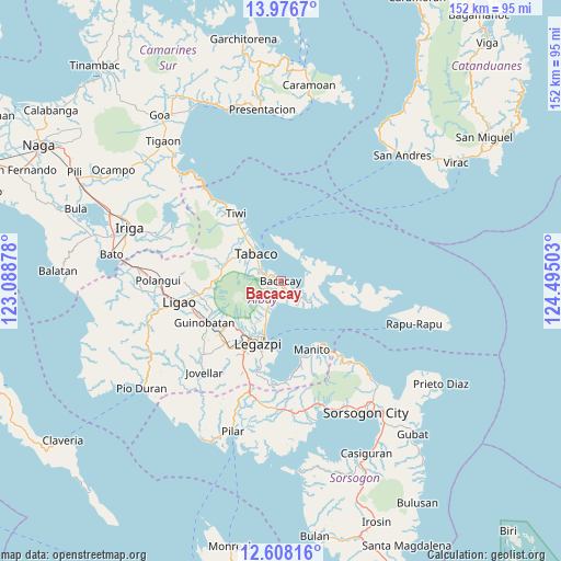
Bacacay GPS coordinates[2]
13° 17' 36.24" North, 123° 47' 30.84" East
| Map corner | latitude | longitude |
|---|---|---|
| Upper-left | 13.9767°, | 123.08878° |
| Center: | 13.2934°, | 123.7919° |
| Lower-right: | 12.60816°, | 124.49503° |
| Map W x H: | 152.2×152.2 km | = 94.6×94.6mi |
| max Lat: | 20.78733° ⇑40% North |
| Bacacay: | 13.2934° |
| min Lat: | ⇓60% South 4.65442° |
| min Long | Bacacay | max Long |
| 117.04868° | 123.7919° | 126.58417° |
| W 67.9%⇐ | ⇒32.1% E |
Elevation
Elevation of Bacacay is 5 m = 16 ft, and this is 82.9 m = 272 ft below average elevation for this country.
| Max E: |
2262 m = 7421 ft | 95.5% |
| Avg. | 87.9 m = 288 ft | |
| Bacacay | 5 m = 16 ft | |
Min E: |
-2 m = -7 ft | 4.5% |
See also: Philippines elevation on elevation.city.
Geographical zone
Bacacay is located in North Torrid zone (between Equator and Tropic of Cancer). Distance of this Northern Tropic circle is 1127.8 km =700.8 mi to North.| Distance of | km | miles | from Bacacay |
|---|---|---|---|
| North Pole | 8529 | 5299.7 | to North |
| Arctic Circle | 5923.1 | 3680.4 | to North |
| Tropic Cancer | 1127.8 | 700.8 | to North |
| Equator | 1478.1 | 918.4 | to South |


Nearby cities:
15 places around Bacacay: (largest is in red/bold)
• Balading
13.8 km =8.6 mi,  321°
321°
• Banag
13.5 km =8.4 mi,  314°
314°
• Bigaa
11.1 km =6.9 mi,  200°
200°
• Binitayan
3.7 km =2.3 mi,  271°
271°
• Bonga
3.9 km =2.4 mi,  247°
247°
• Libog
6.7 km =4.2 mi,  193°
193°
• Malilipot
6.4 km =4 mi,  296°
296°
• Miliroc
11.3 km =7 mi, 300°
• Padang
8.7 km =5.4 mi, 199°
• San Andres
3.8 km =2.4 mi, 200°
• San Francisco
5.2 km =3.2 mi, 299°
• San Roque
5.5 km =3.4 mi,  258°
258°
• Santo Domingo
6.7 km =4.2 mi, 193°
• Sugcad
12.9 km =8 mi, 309°
• Tabaco
9.6 km =6 mi, 318°
Sources, notices
• [Note1] Compared only with cities in Philippines existing in our database
• [Src1] Map data: © OpenStreetMap contributors (CC-BY-SA)
• [Src2] Other city data from geonames.org with taken over terms of usage.
• [Src3] Geographical zone / Annual Mean Temperature by Robert A. Rohde @ Wikipedia
