Bingawan geodata
Bingawan (Western Visayas) is a seat of a third-order administrative division; located in Philippines in Asia/Manila (GMT+8) time zone. With population of 3,657 people, there are 1943 cities with bigger population in this country. Compared to other cities in Philippines, 54.2% of cities are located further ↑North; 53.4% of cities are located further →East and 78.3% of cities have lower elevation than Bingawan. Note1


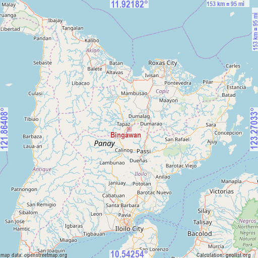
Bingawan GPS coordinates[2]
11° 13' 58.8" North, 122° 34' 1.92" East
| Map corner | latitude | longitude |
|---|---|---|
| Upper-left | 11.92182°, | 121.86408° |
| Center: | 11.233°, | 122.5672° |
| Lower-right: | 10.54254°, | 123.27033° |
| Map W x H: | 153.4×153.4 km | = 95.3×95.3mi |
| max Lat: | 20.78733° ⇑54.2% North |
| Bingawan: | 11.233° |
| min Lat: | ⇓45.8% South 4.65442° |
| min Long | Bingawan | max Long |
| 117.04868° | 122.5672° | 126.58417° |
| W 46.6%⇐ | ⇒53.4% E |
Elevation
Elevation of Bingawan is 81 m = 266 ft, and this is 6.9 m = 23 ft below average elevation for this country.
| Max E: |
2262 m = 7421 ft | 21.7% |
| Avg. | 87.9 m = 288 ft | |
| Bingawan | 81 m = 266 ft | |
Min E: |
-2 m = -7 ft | 78.3% |
See also: Philippines elevation on elevation.city.
Geographical zone
Bingawan is located in North Torrid zone (between Equator and Tropic of Cancer). Distance of Equator is 1249 km =776.1 mi to South.| Distance of | km | miles | from Bingawan |
|---|---|---|---|
| North Pole | 8758.1 | 5442 | to North |
| Arctic Circle | 6152.2 | 3822.8 | to North |
| Tropic Cancer | 1356.9 | 843.1 | to North |
| Equator | 1249 | 776.1 | to South |


Nearby cities:
15 places around Bingawan: (largest is in red/bold)
• Aglalana
11.5 km =7.1 mi,  120°
120°
• Badlan
11.4 km =7.1 mi,  206°
206°
• Bungsuan
14.2 km =8.8 mi,  86°
86°
• Calinog
12.9 km =8 mi,  180°
180°
• Candelaria
7.9 km =4.9 mi,  322°
322°
• Consolacion
12.8 km =8 mi,  34°
34°
• Dumalag
10.4 km =6.5 mi,  36°
36°
• Dumarao
13.8 km =8.6 mi,  74°
74°
• Duran
4.2 km =2.6 mi, 39°
• Maribong
15.2 km =9.4 mi,  194°
194°
• Quinagaringan
12.5 km =7.8 mi,  169°
169°
• San Miguel
3.4 km =2.1 mi,  232°
232°
• San Nicolas
11.2 km =7 mi,  331°
331°
• Santa Angel
11.5 km =7.1 mi, 44°
• Tapas
4.6 km =2.9 mi,  313°
313°
Sources, notices
• [Note1] Compared only with cities in Philippines existing in our database
• [Src1] Map data: © OpenStreetMap contributors (CC-BY-SA)
• [Src2] Other city data from geonames.org with taken over terms of usage.
• [Src3] Geographical zone / Annual Mean Temperature by Robert A. Rohde @ Wikipedia
