Consolacion geodata
Consolacion (Western Visayas) is a populated place; located in Philippines in Asia/Manila (GMT+8) time zone. With population of 2,092 people, there are 4084 cities with bigger population in this country. Compared to other cities in Philippines, 52.9% of cities are located further ↑North; 52.5% of cities are located further →East and 62.9% of cities have lower elevation than Consolacion. Note1


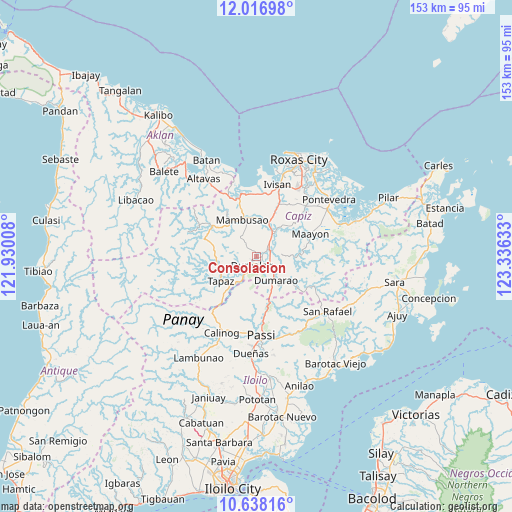
Consolacion GPS coordinates[2]
11° 19' 42.24" North, 122° 37' 59.52" East
| Map corner | latitude | longitude |
|---|---|---|
| Upper-left | 12.01698°, | 121.93008° |
| Center: | 11.3284°, | 122.6332° |
| Lower-right: | 10.63816°, | 123.33633° |
| Map W x H: | 153.3×153.3 km | = 95.3×95.3mi |
| max Lat: | 20.78733° ⇑52.9% North |
| Consolacion: | 11.3284° |
| min Lat: | ⇓47.1% South 4.65442° |
| min Long | Consolacion | max Long |
| 117.04868° | 122.6332° | 126.58417° |
| W 47.5%⇐ | ⇒52.5% E |
Elevation
Elevation of Consolacion is 38 m = 125 ft, and this is 49.9 m = 164 ft below average elevation for this country.
| Max E: |
2262 m = 7421 ft | 37.1% |
| Avg. | 87.9 m = 288 ft | |
| Consolacion | 38 m = 125 ft | |
Min E: |
-2 m = -7 ft | 62.9% |
See also: Philippines elevation on elevation.city.
Geographical zone
Consolacion is located in North Torrid zone (between Equator and Tropic of Cancer). Distance of Equator is 1259.6 km =782.7 mi to South.| Distance of | km | miles | from Consolacion |
|---|---|---|---|
| North Pole | 8747.5 | 5435.4 | to North |
| Arctic Circle | 6141.6 | 3816.2 | to North |
| Tropic Cancer | 1346.3 | 836.6 | to North |
| Equator | 1259.6 | 782.7 | to South |


Nearby cities:
15 places around Consolacion: (largest is in red/bold)
• Bingawan
12.8 km =8 mi,  214°
214°
• Bungsuan
12 km =7.5 mi,  144°
144°
• Candelaria
12.8 km =8 mi,  250°
250°
• Cuartero
4.2 km =2.6 mi,  70°
70°
• Dao
9.2 km =5.7 mi,  38°
38°
• Dumalag
2.5 km =1.6 mi,  204°
204°
• Dumarao
9.3 km =5.8 mi, 139°
• Duran
8.7 km =5.4 mi, 211°
• Mambusao
12.3 km =7.6 mi,  341°
341°
• Mangoso
9.9 km =6.2 mi,  3°
3°
• Manjoy
4.6 km =2.9 mi,  52°
52°
• Masonogan
6.4 km =4 mi, 45°
• San Nicolas
12.5 km =7.8 mi,  266°
266°
• Santa Angel
2.5 km =1.6 mi,  160°
160°
• Sigma
10.9 km =6.8 mi,  19°
19°
Sources, notices
• [Note1] Compared only with cities in Philippines existing in our database
• [Src1] Map data: © OpenStreetMap contributors (CC-BY-SA)
• [Src2] Other city data from geonames.org with taken over terms of usage.
• [Src3] Geographical zone / Annual Mean Temperature by Robert A. Rohde @ Wikipedia
