Panabo geodata
Panabo (Davao) is a populated place; located in Philippines in Asia/Manila (GMT+8) time zone. With population of 84,749 people, there are 107 cities with bigger population in this country. Compared to other cities in Philippines, 88.5% of cities are located further ↑North; 95.5% of cities are located further ←West and 97.1% of cities have higher elevation than Panabo. Note1
Administrative division(s):
- Level 1: Davao
- Level 2: Province of Davao del Norte
- Level 3: City of Panabo


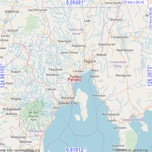
Panabo GPS coordinates[2]
7° 18' 29.016" North, 125° 41' 3.012" East
| Map corner | latitude | longitude |
|---|---|---|
| Upper-left | 8.00491°, | 124.98105° |
| Center: | 7.30806°, | 125.68417° |
| Lower-right: | 6.61012°, | 126.3873° |
| Map W x H: | 155.1×155.1 km | = 96.4×96.4mi |
| max Lat: | 20.78733° ⇑88.5% North |
| Panabo: | 7.30806° |
| min Lat: | ⇓11.5% South 4.65442° |
| min Long | Panabo | max Long |
| 117.04868° | 125.68417° | 126.58417° |
| W 95.5%⇐ | ⇒4.5% E |
Elevation
Elevation of Panabo is 4 m = 13 ft, and this is 83.9 m = 275 ft below average elevation for this country.
| Max E: |
2262 m = 7421 ft | 97.1% |
| Avg. | 87.9 m = 288 ft | |
| Panabo | 4 m = 13 ft | |
Min E: |
-2 m = -7 ft | 2.9% |
See also: Panabo elevation on elevation.city.
Geographical zone
Panabo is located in North Torrid zone (between Equator and Tropic of Cancer). Distance of Equator is 812.6 km =504.9 mi to South.| Distance of | km | miles | from Panabo |
|---|---|---|---|
| North Pole | 9194.5 | 5713.2 | to North |
| Arctic Circle | 6588.6 | 4094 | to North |
| Tropic Cancer | 1793.3 | 1114.3 | to North |
| Equator | 812.6 | 504.9 | to South |


Nearby cities:
15 places around Panabo: (largest is in red/bold)
• Alejal
8.9 km =5.5 mi,  342°
342°
• Anibongan
10.2 km =6.3 mi,  21°
21°
• Bincoñgan
9.8 km =6.1 mi,  48°
48°
• Carmen
6.3 km =3.9 mi, 22°
• Katipunan
7.2 km =4.5 mi,  280°
280°
• La Paz
5.5 km =3.4 mi,  80°
80°
• Lasang
5 km =3.1 mi,  204°
204°
• Libuganon
11.3 km =7 mi,  66°
66°
• Maduao
6.6 km =4.1 mi,  256°
256°
• Magsaysay
11.2 km =7 mi,  331°
331°
• Manaloal
7 km =4.3 mi, 337°
• Nanyo
5.8 km =3.6 mi,  298°
298°
• Santo Niño
3.2 km =2 mi, 46°
• Tubod
8.3 km =5.2 mi, 328°
• Tuganay
8 km =5 mi,  32°
32°
Sources, notices
• [Note1] Compared only with cities in Philippines existing in our database
• [Src1] Map data: © OpenStreetMap contributors (CC-BY-SA)
• [Src2] Other city data from geonames.org with taken over terms of usage.
• [Src3] Geographical zone / Annual Mean Temperature by Robert A. Rohde @ Wikipedia
