Biñan geodata
Biñan (Calabarzon) is a seat of a third-order administrative division; located in Philippines in Asia/Manila (GMT+8) time zone. With population of 300,000 people, there are 30 cities with bigger population in this country. Compared to other cities in Philippines, 73.3% of cities are located further ↓South; 74.4% of cities are located further →East and 76.6% of cities have higher elevation than Biñan. Note1


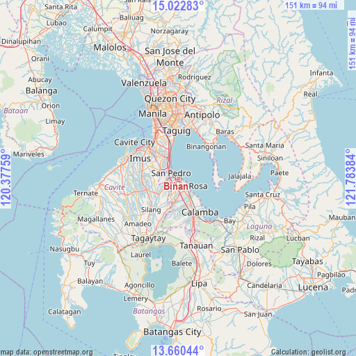
Biñan GPS coordinates[2]
14° 20' 33.612" North, 121° 4' 50.556" East
| Map corner | latitude | longitude |
|---|---|---|
| Upper-left | 15.02283°, | 120.37759° |
| Center: | 14.34267°, | 121.08071° |
| Lower-right: | 13.66044°, | 121.78384° |
| Map W x H: | 151.5×151.5 km | = 94.1×94.1mi |
| max Lat: | 20.78733° ⇑26.7% North |
| Biñan: | 14.34267° |
| min Lat: | ⇓73.3% South 4.65442° |
| min Long | Biñan | max Long |
| 117.04868° | 121.08071° | 126.58417° |
| W 25.6%⇐ | ⇒74.4% E |
Elevation
Elevation of Biñan is 10 m = 33 ft, and this is 77.9 m = 256 ft below average elevation for this country.
| Max E: |
2262 m = 7421 ft | 76.6% |
| Avg. | 87.9 m = 288 ft | |
| Biñan | 10 m = 33 ft | |
Min E: |
-2 m = -7 ft | 23.4% |
See also: Biñan elevation on elevation.city.
Geographical zone
Biñan is located in North Torrid zone (between Equator and Tropic of Cancer). Distance of this Northern Tropic circle is 1011.2 km =628.3 mi to North.| Distance of | km | miles | from Biñan |
|---|---|---|---|
| North Pole | 8412.3 | 5227.2 | to North |
| Arctic Circle | 5806.4 | 3607.9 | to North |
| Tropic Cancer | 1011.2 | 628.3 | to North |
| Equator | 1594.8 | 991 | to South |


Nearby cities:
15 places around Biñan: (largest is in red/bold)
• Aplaya
4.3 km =2.7 mi,  124°
124°
• Biga
15.1 km =9.4 mi,  231°
231°
• Bulihan
11.7 km =7.3 mi, 232°
• Cabuyao
9.2 km =5.7 mi,  147°
147°
• Carmona
4.1 km =2.5 mi,  217°
217°
• Gulod
14.8 km =9.2 mi,  89°
89°
• Magsaysay
5 km =3.1 mi,  265°
265°
• Maguyam
12.1 km =7.5 mi, 222°
• Mamatid
14.7 km =9.1 mi,  144°
144°
• Muntinlupa
6.4 km =4 mi,  325°
325°
• Pulong Santa Cruz
7.7 km =4.8 mi,  183°
183°
• Puting Kahoy
15.1 km =9.4 mi,  200°
200°
• Sambayanihan People's Village
15.4 km =9.6 mi,  324°
324°
• San Pedro
4.1 km =2.5 mi,  297°
297°
• Santa Rosa
4.7 km =2.9 mi, 135°
Sources, notices
• [Note1] Compared only with cities in Philippines existing in our database
• [Src1] Map data: © OpenStreetMap contributors (CC-BY-SA)
• [Src2] Other city data from geonames.org with taken over terms of usage.
• [Src3] Geographical zone / Annual Mean Temperature by Robert A. Rohde @ Wikipedia
