San Pedro geodata
San Pedro (Calabarzon) is a seat of a third-order administrative division; located in Philippines in Asia/Manila (GMT+8) time zone. With population of 270,216 people, there are 35 cities with bigger population in this country. Compared to other cities in Philippines, 73.4% of cities are located further ↓South; 75.2% of cities are located further →East and 59.2% of cities have higher elevation than San Pedro. Note1
Administrative division(s):
- Level 1: Calabarzon
- Level 2: Province of Laguna
- Level 3: City of San Pedro


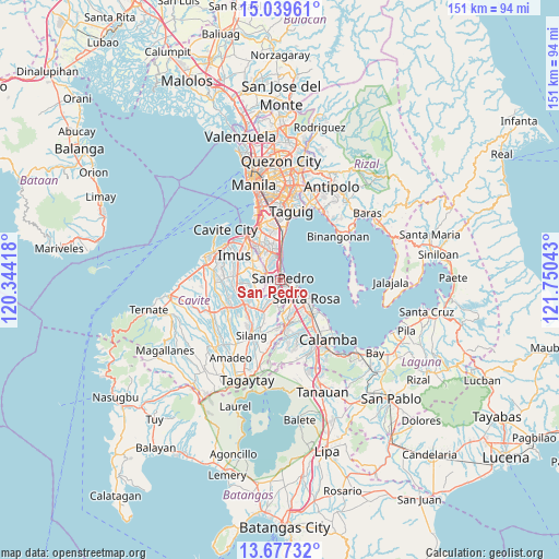
San Pedro GPS coordinates[2]
14° 21' 34.2" North, 121° 2' 50.28" East
| Map corner | latitude | longitude |
|---|---|---|
| Upper-left | 15.03961°, | 120.34418° |
| Center: | 14.3595°, | 121.0473° |
| Lower-right: | 13.67732°, | 121.75043° |
| Map W x H: | 151.5×151.5 km | = 94.1×94.1mi |
| max Lat: | 20.78733° ⇑26.6% North |
| San Pedro: | 14.3595° |
| min Lat: | ⇓73.4% South 4.65442° |
| min Long | San Pedro | max Long |
| 117.04868° | 121.0473° | 126.58417° |
| W 24.8%⇐ | ⇒75.2% E |
Elevation
Elevation of San Pedro is 17 m = 56 ft, and this is 70.9 m = 233 ft below average elevation for this country.
| Max E: |
2262 m = 7421 ft | 59.2% |
| Avg. | 87.9 m = 288 ft | |
| San Pedro | 17 m = 56 ft | |
Min E: |
-2 m = -7 ft | 40.8% |
See also: San Pedro elevation on elevation.city.
Geographical zone
San Pedro is located in North Torrid zone (between Equator and Tropic of Cancer). Distance of this Northern Tropic circle is 1009.3 km =627.1 mi to North.| Distance of | km | miles | from San Pedro |
|---|---|---|---|
| North Pole | 8410.4 | 5226 | to North |
| Arctic Circle | 5804.5 | 3606.7 | to North |
| Tropic Cancer | 1009.3 | 627.1 | to North |
| Equator | 1596.6 | 992.1 | to South |


Nearby cities:
15 places around San Pedro: (largest is in red/bold)
• Aplaya
8.3 km =5.2 mi,  120°
120°
• Biga
13.9 km =8.6 mi,  215°
215°
• Biñan
4.1 km =2.5 mi, 117°
• Bulihan
10.7 km =6.6 mi,  211°
211°
• Cabuyao
12.9 km =8 mi,  138°
138°
• Carmona
5.3 km =3.3 mi,  167°
167°
• Dasmariñas
12.4 km =7.7 mi,  254°
254°
• Imus
14.2 km =8.8 mi,  303°
303°
• Las Piñas
12.3 km =7.6 mi,  325°
325°
• Magsaysay
2.7 km =1.7 mi, 211°
• Maguyam
11.7 km =7.3 mi,  202°
202°
• Muntinlupa
3.4 km =2.1 mi,  0°
0°
• Pulong Santa Cruz
10.1 km =6.3 mi,  161°
161°
• Sambayanihan People's Village
11.9 km =7.4 mi, 333°
• Santa Rosa
8.7 km =5.4 mi,  127°
127°
Sources, notices
• [Note1] Compared only with cities in Philippines existing in our database
• [Src1] Map data: © OpenStreetMap contributors (CC-BY-SA)
• [Src2] Other city data from geonames.org with taken over terms of usage.
• [Src3] Geographical zone / Annual Mean Temperature by Robert A. Rohde @ Wikipedia
