Bulihan geodata
Bulihan (Calabarzon) is a populated place; located in Philippines in Asia/Manila (GMT+8) time zone. With population of 13,979 people, there are 470 cities with bigger population in this country. Compared to other cities in Philippines, 72.6% of cities are located further ↓South; 76.4% of cities are located further →East and 89.1% of cities have lower elevation than Bulihan. Note1


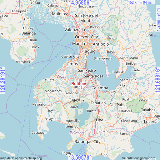
Bulihan GPS coordinates[2]
14° 16' 41.52" North, 120° 59' 42.108" East
| Map corner | latitude | longitude |
|---|---|---|
| Upper-left | 14.95856°, | 120.29191° |
| Center: | 14.2782°, | 120.99503° |
| Lower-right: | 13.59578°, | 121.69816° |
| Map W x H: | 151.5×151.5 km | = 94.1×94.1mi |
| max Lat: | 20.78733° ⇑27.4% North |
| Bulihan: | 14.2782° |
| min Lat: | ⇓72.6% South 4.65442° |
| min Long | Bulihan | max Long |
| 117.04868° | 120.99503° | 126.58417° |
| W 23.6%⇐ | ⇒76.4% E |
Elevation
Elevation of Bulihan is 204 m = 669 ft, and this is 116.1 m = 381 ft above average elevation for this country.
| Max E: |
2262 m = 7421 ft | 10.9% |
| Bulihan | 204 m 669 ft | |
| Avg. | 87.9 m = 288 ft | |
Min E: |
-2 m = -7 ft | 89.1% |
See also: Philippines elevation on elevation.city.
Geographical zone
Bulihan is located in North Torrid zone (between Equator and Tropic of Cancer). Distance of this Northern Tropic circle is 1018.3 km =632.7 mi to North.| Distance of | km | miles | from Bulihan |
|---|---|---|---|
| North Pole | 8419.5 | 5231.6 | to North |
| Arctic Circle | 5813.6 | 3612.4 | to North |
| Tropic Cancer | 1018.3 | 632.7 | to North |
| Equator | 1587.6 | 986.5 | to South |


Nearby cities:
15 places around Bulihan: (largest is in red/bold)
• Aliang
12 km =7.5 mi,  272°
272°
• Balite Segundo
10.8 km =6.7 mi,  191°
191°
• Biga
3.4 km =2.1 mi,  227°
227°
• Biñan
11.7 km =7.3 mi,  52°
52°
• Carmona
7.8 km =4.8 mi,  60°
60°
• Dasmariñas
8.5 km =5.3 mi,  312°
312°
• Javalera
8.8 km =5.5 mi,  255°
255°
• Lumil
10.9 km =6.8 mi,  171°
171°
• Magsaysay
7.9 km =4.9 mi,  31°
31°
• Maguyam
2 km =1.2 mi,  147°
147°
• Manggahan
10.2 km =6.3 mi,  278°
278°
• Pulong Santa Cruz
8.8 km =5.5 mi,  93°
93°
• Puting Kahoy
8 km =5 mi, 150°
• San Pedro
10.7 km =6.6 mi, 31°
• Silang
7.4 km =4.6 mi,  200°
200°
Sources, notices
• [Note1] Compared only with cities in Philippines existing in our database
• [Src1] Map data: © OpenStreetMap contributors (CC-BY-SA)
• [Src2] Other city data from geonames.org with taken over terms of usage.
• [Src3] Geographical zone / Annual Mean Temperature by Robert A. Rohde @ Wikipedia
