Catigbian geodata
Catigbian (Central Visayas) is a seat of a third-order administrative division; located in Philippines in Asia/Manila (GMT+8) time zone. In our database, there are 4166 cities with bigger population. Compared to other cities in Philippines, 69.9% of cities are located further ↑North; 70.9% of cities are located further ←West and 89.8% of cities have lower elevation than Catigbian. Note1


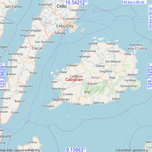
Catigbian GPS coordinates[2]
9° 51' 0.36" North, 123° 59' 57.84" East
| Map corner | latitude | longitude |
|---|---|---|
| Upper-left | 10.54212°, | 123.29628° |
| Center: | 9.8501°, | 123.9994° |
| Lower-right: | 9.15663°, | 124.70253° |
| Map W x H: | 154.1×154.1 km | = 95.8×95.8mi |
| max Lat: | 20.78733° ⇑69.9% North |
| Catigbian: | 9.8501° |
| min Lat: | ⇓30.1% South 4.65442° |
| min Long | Catigbian | max Long |
| 117.04868° | 123.9994° | 126.58417° |
| W 70.9%⇐ | ⇒29.1% E |
Elevation
Elevation of Catigbian is 224 m = 735 ft, and this is 136.1 m = 447 ft above average elevation for this country.
| Max E: |
2262 m = 7421 ft | 10.2% |
| Catigbian | 224 m 735 ft | |
| Avg. | 87.9 m = 288 ft | |
Min E: |
-2 m = -7 ft | 89.8% |
See also: Philippines elevation on elevation.city.
Geographical zone
Catigbian is located in North Torrid zone (between Equator and Tropic of Cancer). Distance of Equator is 1095.2 km =680.5 mi to South.| Distance of | km | miles | from Catigbian |
|---|---|---|---|
| North Pole | 8911.8 | 5537.5 | to North |
| Arctic Circle | 6305.9 | 3918.3 | to North |
| Tropic Cancer | 1510.7 | 938.7 | to North |
| Equator | 1095.2 | 680.5 | to South |


Nearby cities:
15 places around Catigbian: (largest is in red/bold)
• Abucayan
12.8 km =8 mi,  313°
313°
• Antequera
13.4 km =8.3 mi,  235°
235°
• Bagacay
9.1 km =5.7 mi,  281°
281°
• Balilihan
10.8 km =6.7 mi,  195°
195°
• Batuan
18.1 km =11.2 mi,  115°
115°
• Calape
14.4 km =8.9 mi,  288°
288°
• Canmaya Diot
14.3 km =8.9 mi,  46°
46°
• Clarin
12.7 km =7.9 mi,  12°
12°
• Nahawan
14.5 km =9 mi,  21°
21°
• Panaytayon
11.2 km =7 mi,  350°
350°
• Pinayagan Norte
10.7 km =6.6 mi,  329°
329°
• Sagbayan
12.4 km =7.7 mi, 54°
• San Isidro
14.7 km =9.1 mi,  300°
300°
• Sevilla
17.1 km =10.6 mi,  161°
161°
• Tibigan
12 km =7.5 mi,  340°
340°
Sources, notices
• [Note1] Compared only with cities in Philippines existing in our database
• [Src1] Map data: © OpenStreetMap contributors (CC-BY-SA)
• [Src2] Other city data from geonames.org with taken over terms of usage.
• [Src3] Geographical zone / Annual Mean Temperature by Robert A. Rohde @ Wikipedia
