Sevilla geodata
Sevilla (Central Visayas) is a seat of a third-order administrative division; located in Philippines in Asia/Manila (GMT+8) time zone. In our database, there are 4166 cities with bigger population. Compared to other cities in Philippines, 71.6% of cities are located further ↑North; 72.1% of cities are located further ←West and 75.5% of cities have lower elevation than Sevilla. Note1


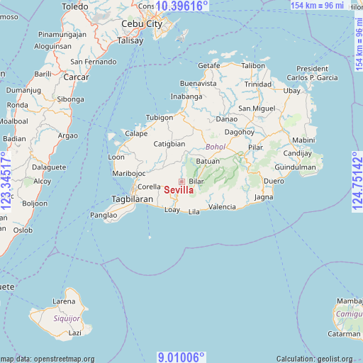
Sevilla GPS coordinates[2]
9° 42' 13.788" North, 124° 2' 53.844" East
| Map corner | latitude | longitude |
|---|---|---|
| Upper-left | 10.39616°, | 123.34517° |
| Center: | 9.70383°, | 124.04829° |
| Lower-right: | 9.01006°, | 124.75142° |
| Map W x H: | 154.1×154.1 km | = 95.8×95.8mi |
| max Lat: | 20.78733° ⇑71.6% North |
| Sevilla: | 9.70383° |
| min Lat: | ⇓28.4% South 4.65442° |
| min Long | Sevilla | max Long |
| 117.04868° | 124.04829° | 126.58417° |
| W 72.1%⇐ | ⇒27.9% E |
Elevation
Elevation of Sevilla is 70 m = 230 ft, and this is 17.9 m = 59 ft below average elevation for this country.
| Max E: |
2262 m = 7421 ft | 24.5% |
| Avg. | 87.9 m = 288 ft | |
| Sevilla | 70 m = 230 ft | |
Min E: |
-2 m = -7 ft | 75.5% |
See also: Philippines elevation on elevation.city.
Geographical zone
Sevilla is located in North Torrid zone (between Equator and Tropic of Cancer). Distance of Equator is 1079 km =670.5 mi to South.| Distance of | km | miles | from Sevilla |
|---|---|---|---|
| North Pole | 8928.1 | 5547.7 | to North |
| Arctic Circle | 6322.2 | 3928.4 | to North |
| Tropic Cancer | 1527 | 948.8 | to North |
| Equator | 1079 | 670.5 | to South |


Nearby cities:
15 places around Sevilla: (largest is in red/bold)
• Alburquerque
14.5 km =9 mi,  222°
222°
• Antequera
18.5 km =11.5 mi,  297°
297°
• Balilihan
10.1 km =6.3 mi,  305°
305°
• Batuan
13.9 km =8.6 mi,  52°
52°
• Bilar
6.5 km =4 mi,  85°
85°
• Catigbian
17.1 km =10.6 mi,  341°
341°
• Corella
14 km =8.7 mi,  262°
262°
• Cortes
18.6 km =11.6 mi,  276°
276°
• Danao
18.4 km =11.4 mi,  115°
115°
• Dimiao
16.6 km =10.3 mi,  130°
130°
• Lila
13.5 km =8.4 mi,  157°
157°
• Loay
12.1 km =7.5 mi,  198°
198°
• Loboc
7.4 km =4.6 mi,  191°
191°
• Nueva Vida Sur
16.5 km =10.3 mi,  57°
57°
• Sikatuna
8.2 km =5.1 mi, 257°
Sources, notices
• [Note1] Compared only with cities in Philippines existing in our database
• [Src1] Map data: © OpenStreetMap contributors (CC-BY-SA)
• [Src2] Other city data from geonames.org with taken over terms of usage.
• [Src3] Geographical zone / Annual Mean Temperature by Robert A. Rohde @ Wikipedia
