Canmaya Diot geodata
Canmaya Diot (Central Visayas) is a populated place; located in Philippines in Asia/Manila (GMT+8) time zone. With population of 2,610 people, there are 3091 cities with bigger population in this country. Compared to other cities in Philippines, 68.9% of cities are located further ↑North; 72.7% of cities are located further ←West and 90.2% of cities have lower elevation than Canmaya Diot. Note1


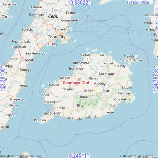
Canmaya Diot GPS coordinates[2]
9° 56' 18.24" North, 124° 5' 39.12" East
| Map corner | latitude | longitude |
|---|---|---|
| Upper-left | 10.63022°, | 123.39108° |
| Center: | 9.9384°, | 124.0942° |
| Lower-right: | 9.24511°, | 124.79733° |
| Map W x H: | 154×154 km | = 95.7×95.7mi |
| max Lat: | 20.78733° ⇑68.9% North |
| Canmaya Diot: | 9.9384° |
| min Lat: | ⇓31.1% South 4.65442° |
| min Long | Canmaya Diot | max Long |
| 117.04868° | 124.0942° | 126.58417° |
| W 72.7%⇐ | ⇒27.3% E |
Elevation
Elevation of Canmaya Diot is 233 m = 764 ft, and this is 145.1 m = 476 ft above average elevation for this country.
| Max E: |
2262 m = 7421 ft | 9.8% |
| Canmaya Diot | 233 m 764 ft | |
| Avg. | 87.9 m = 288 ft | |
Min E: |
-2 m = -7 ft | 90.2% |
See also: Philippines elevation on elevation.city.
Geographical zone
Canmaya Diot is located in North Torrid zone (between Equator and Tropic of Cancer). Distance of Equator is 1105 km =686.6 mi to South.| Distance of | km | miles | from Canmaya Diot |
|---|---|---|---|
| North Pole | 8902 | 5531.4 | to North |
| Arctic Circle | 6296.1 | 3912.2 | to North |
| Tropic Cancer | 1500.9 | 932.6 | to North |
| Equator | 1105 | 686.6 | to South |


Nearby cities:
15 places around Canmaya Diot: (largest is in red/bold)
• Batuan
18.5 km =11.5 mi,  161°
161°
• Buenavista
16.3 km =10.1 mi,  8°
8°
• Buenavista
17.8 km =11.1 mi,  127°
127°
• Carmen
17.1 km =10.6 mi,  139°
139°
• Catigbian
14.3 km =8.9 mi,  226°
226°
• Clarin
8 km =5 mi,  288°
288°
• Danao
14.2 km =8.8 mi,  87°
87°
• Inabanga
10.7 km =6.6 mi,  343°
343°
• Nahawan
6.2 km =3.9 mi,  305°
305°
• Nueva Fuerza
13 km =8.1 mi, 142°
• Nueva Vida Sur
19.2 km =11.9 mi,  152°
152°
• Panaytayon
12.2 km =7.6 mi,  276°
276°
• Pinayagan Norte
15.8 km =9.8 mi,  267°
267°
• Sagbayan
2.7 km =1.7 mi,  185°
185°
• Tibigan
14.5 km =9 mi, 275°
Sources, notices
• [Note1] Compared only with cities in Philippines existing in our database
• [Src1] Map data: © OpenStreetMap contributors (CC-BY-SA)
• [Src2] Other city data from geonames.org with taken over terms of usage.
• [Src3] Geographical zone / Annual Mean Temperature by Robert A. Rohde @ Wikipedia
