Conduaga geodata
Conduaga (Mimaropa) is a populated place; located in Philippines in Asia/Manila (GMT+8) time zone. With population of 5,164 people, there are 1241 cities with bigger population in this country. Compared to other cities in Philippines, 76.6% of cities are located further ↑North; 99.9% of cities are located further →East and 85.4% of cities have higher elevation than Conduaga. Note1


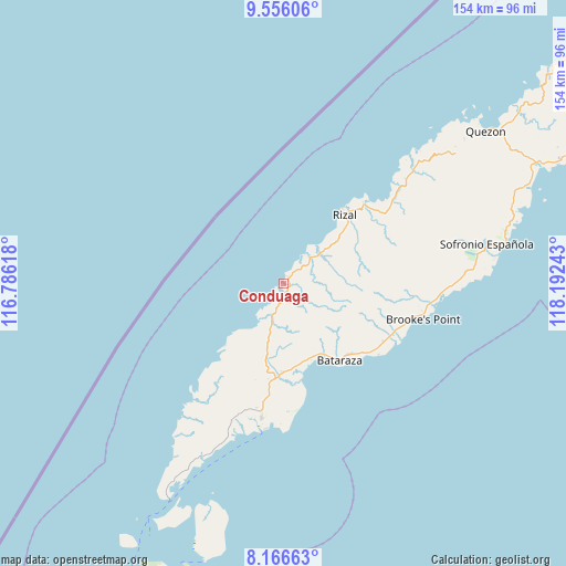
Conduaga GPS coordinates[2]
8° 51' 43.2" North, 117° 29' 21.48" East
| Map corner | latitude | longitude |
|---|---|---|
| Upper-left | 9.55606°, | 116.78618° |
| Center: | 8.862°, | 117.4893° |
| Lower-right: | 8.16663°, | 118.19243° |
| Map W x H: | 154.5×154.5 km | = 96×96mi |
| max Lat: | 20.78733° ⇑76.6% North |
| Conduaga: | 8.862° |
| min Lat: | ⇓23.4% South 4.65442° |
| min Long | Conduaga | max Long |
| 117.04868° | 117.4893° | 126.58417° |
| W 0.1%⇐ | ⇒99.9% E |
Elevation
Elevation of Conduaga is 8 m = 26 ft, and this is 79.9 m = 262 ft below average elevation for this country.
| Max E: |
2262 m = 7421 ft | 85.4% |
| Avg. | 87.9 m = 288 ft | |
| Conduaga | 8 m = 26 ft | |
Min E: |
-2 m = -7 ft | 14.6% |
See also: Philippines elevation on elevation.city.
Geographical zone
Conduaga is located in North Torrid zone (between Equator and Tropic of Cancer). Distance of Equator is 985.4 km =612.3 mi to South.| Distance of | km | miles | from Conduaga |
|---|---|---|---|
| North Pole | 9021.7 | 5605.8 | to North |
| Arctic Circle | 6415.8 | 3986.6 | to North |
| Tropic Cancer | 1620.6 | 1007 | to North |
| Equator | 985.4 | 612.3 | to South |


Nearby cities:
15 places around Conduaga: (largest is in red/bold)
• Barong Barong
44.5 km =27.7 mi,  91°
91°
• Batarasa
25.9 km =16.1 mi,  144°
144°
• Bunog
44.6 km =27.7 mi,  46°
46°
• Eraan
32.3 km =20.1 mi, 46°
• Ipilan
45.5 km =28.3 mi, 92°
• Iraray
63.4 km =39.4 mi,  76°
76°
• Mainit
36.2 km =22.5 mi, 93°
• Panalingaan
11.3 km =7 mi,  220°
220°
• Pañgobilian
41.2 km =25.6 mi,  99°
99°
• Ransang
15 km =9.3 mi,  43°
43°
• Rio Tuba
40.1 km =24.9 mi,  189°
189°
• Saraza
34.9 km =21.7 mi,  113°
113°
• Tagbita
22.5 km =14 mi, 222°
• Tagusao
51.2 km =31.8 mi, 44°
• Tarusan
23.2 km =14.4 mi,  174°
174°
Sources, notices
• [Note1] Compared only with cities in Philippines existing in our database
• [Src1] Map data: © OpenStreetMap contributors (CC-BY-SA)
• [Src2] Other city data from geonames.org with taken over terms of usage.
• [Src3] Geographical zone / Annual Mean Temperature by Robert A. Rohde @ Wikipedia
