Baracatan geodata
Baracatan (Davao) is a populated place; located in Philippines in Asia/Manila (GMT+8) time zone. With population of 7,298 people, there are 855 cities with bigger population in this country. Compared to other cities in Philippines, 92% of cities are located further ↑North; 92.3% of cities are located further ←West and 95.3% of cities have lower elevation than Baracatan. Note1


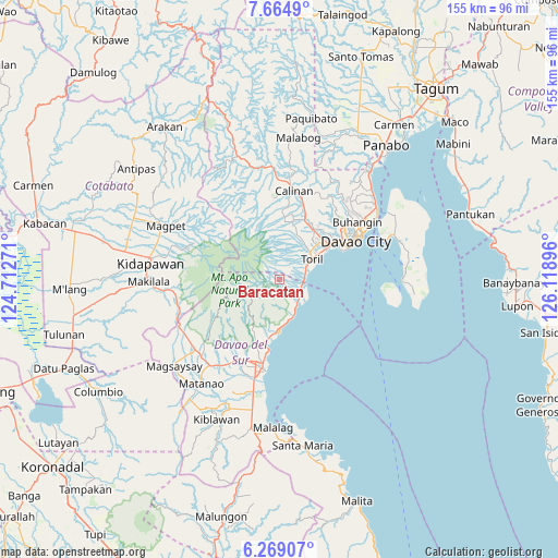
Baracatan GPS coordinates[2]
6° 58' 3" North, 125° 24' 56.988" East
| Map corner | latitude | longitude |
|---|---|---|
| Upper-left | 7.6649°, | 124.71271° |
| Center: | 6.9675°, | 125.41583° |
| Lower-right: | 6.26907°, | 126.11896° |
| Map W x H: | 155.2×155.2 km | = 96.4×96.4mi |
| max Lat: | 20.78733° ⇑92% North |
| Baracatan: | 6.9675° |
| min Lat: | ⇓8% South 4.65442° |
| min Long | Baracatan | max Long |
| 117.04868° | 125.41583° | 126.58417° |
| W 92.3%⇐ | ⇒7.7% E |
Elevation
Elevation of Baracatan is 443 m = 1453 ft, and this is 355.1 m = 1165 ft above average elevation for this country.
| Max E: |
2262 m = 7421 ft | 4.7% |
| Baracatan | 443 m 1453 ft | |
| Avg. | 87.9 m = 288 ft | |
Min E: |
-2 m = -7 ft | 95.3% |
See also: Philippines elevation on elevation.city.
Geographical zone
Baracatan is located in North Torrid zone (between Equator and Tropic of Cancer). Distance of Equator is 774.7 km =481.4 mi to South.| Distance of | km | miles | from Baracatan |
|---|---|---|---|
| North Pole | 9232.3 | 5736.7 | to North |
| Arctic Circle | 6626.5 | 4117.5 | to North |
| Tropic Cancer | 1831.2 | 1137.9 | to North |
| Equator | 774.7 | 481.4 | to South |


Nearby cities:
15 places around Baracatan: (largest is in red/bold)
• Astorga
8 km =5 mi,  146°
146°
• Bato
10.5 km =6.5 mi,  36°
36°
• Coronon
10.5 km =6.5 mi,  159°
159°
• Goma
22.2 km =13.8 mi,  208°
208°
• Inawayan
6.4 km =4 mi,  96°
96°
• Santa Cruz
14.5 km =9 mi,  181°
181°
• Sibulan
6.4 km =4 mi,  126°
126°
• Sirib
18.5 km =11.5 mi,  357°
357°
• Tagakpan
16.2 km =10.1 mi,  5°
5°
• Takub
12.4 km =7.7 mi, 176°
• Tamayong
18.8 km =11.7 mi,  347°
347°
• Tawan tawan
22.9 km =14.2 mi, 348°
• Tuban
16.4 km =10.2 mi,  191°
191°
• Ula
20.2 km =12.6 mi,  24°
24°
• Wañgan
21.6 km =13.4 mi, 8°
Sources, notices
• [Note1] Compared only with cities in Philippines existing in our database
• [Src1] Map data: © OpenStreetMap contributors (CC-BY-SA)
• [Src2] Other city data from geonames.org with taken over terms of usage.
• [Src3] Geographical zone / Annual Mean Temperature by Robert A. Rohde @ Wikipedia
