Coronon geodata
Coronon (Davao) is a populated place; located in Philippines in Asia/Manila (GMT+8) time zone. With population of 6,854 people, there are 908 cities with bigger population in this country. Compared to other cities in Philippines, 92.7% of cities are located further ↑North; 92.8% of cities are located further ←West and 54.5% of cities have higher elevation than Coronon. Note1


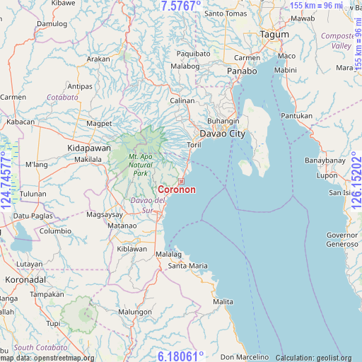
Coronon GPS coordinates[2]
6° 52' 45.012" North, 125° 26' 56.004" East
| Map corner | latitude | longitude |
|---|---|---|
| Upper-left | 7.5767°, | 124.74577° |
| Center: | 6.87917°, | 125.44889° |
| Lower-right: | 6.18061°, | 126.15202° |
| Map W x H: | 155.2×155.2 km | = 96.4×96.4mi |
| max Lat: | 20.78733° ⇑92.7% North |
| Coronon: | 6.87917° |
| min Lat: | ⇓7.3% South 4.65442° |
| min Long | Coronon | max Long |
| 117.04868° | 125.44889° | 126.58417° |
| W 92.8%⇐ | ⇒7.2% E |
Elevation
Elevation of Coronon is 20 m = 66 ft, and this is 67.9 m = 223 ft below average elevation for this country.
| Max E: |
2262 m = 7421 ft | 54.5% |
| Avg. | 87.9 m = 288 ft | |
| Coronon | 20 m = 66 ft | |
Min E: |
-2 m = -7 ft | 45.5% |
See also: Philippines elevation on elevation.city.
Geographical zone
Coronon is located in North Torrid zone (between Equator and Tropic of Cancer). Distance of Equator is 764.9 km =475.3 mi to South.| Distance of | km | miles | from Coronon |
|---|---|---|---|
| North Pole | 9242.2 | 5742.8 | to North |
| Arctic Circle | 6636.3 | 4123.6 | to North |
| Tropic Cancer | 1841 | 1143.9 | to North |
| Equator | 764.9 | 475.3 | to South |


Nearby cities:
15 places around Coronon: (largest is in red/bold)
• Astorga
3.2 km =2 mi,  13°
13°
• Balutakay
20.6 km =12.8 mi,  211°
211°
• Baracatan
10.5 km =6.5 mi,  339°
339°
• Bato
18.4 km =11.4 mi, 8°
• Digos
17.6 km =10.9 mi,  215°
215°
• Goma
17.1 km =10.6 mi,  235°
235°
• Guihing Proper
24.1 km =15 mi, 206°
• Inawayan
9.5 km =5.9 mi,  16°
16°
• Managa
24.8 km =15.4 mi,  233°
233°
• Matti
19.6 km =12.2 mi, 232°
• Santa Cruz
6.1 km =3.8 mi, 220°
• Sibulan
6.2 km =3.9 mi, 13°
• Sinayawan
24.1 km =15 mi, 219°
• Takub
3.9 km =2.4 mi, 228°
• Tuban
9.3 km =5.8 mi, 227°
Sources, notices
• [Note1] Compared only with cities in Philippines existing in our database
• [Src1] Map data: © OpenStreetMap contributors (CC-BY-SA)
• [Src2] Other city data from geonames.org with taken over terms of usage.
• [Src3] Geographical zone / Annual Mean Temperature by Robert A. Rohde @ Wikipedia
