Bangad geodata
Bangad (Central Luzon) is a populated place; located in Philippines in Asia/Manila (GMT+8) time zone. With population of 4,498 people, there are 1491 cities with bigger population in this country. Compared to other cities in Philippines, 81.8% of cities are located further ↓South; 75.7% of cities are located further →East and 66.4% of cities have lower elevation than Bangad. Note1
Administrative division(s):
- Level 1: Central Luzon
- Level 2: Province of Nueva Ecija
- Level 3: Cabanatuan City


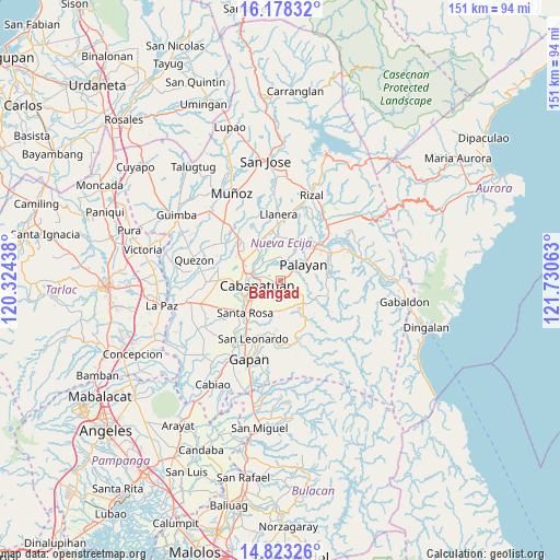
Bangad GPS coordinates[2]
15° 30' 6.84" North, 121° 1' 39" East
| Map corner | latitude | longitude |
|---|---|---|
| Upper-left | 16.17832°, | 120.32438° |
| Center: | 15.5019°, | 121.0275° |
| Lower-right: | 14.82326°, | 121.73063° |
| Map W x H: | 150.7×150.7 km | = 93.6×93.6mi |
| max Lat: | 20.78733° ⇑18.2% North |
| Bangad: | 15.5019° |
| min Lat: | ⇓81.8% South 4.65442° |
| min Long | Bangad | max Long |
| 117.04868° | 121.0275° | 126.58417° |
| W 24.3%⇐ | ⇒75.7% E |
Elevation
Elevation of Bangad is 44 m = 144 ft, and this is 43.9 m = 144 ft below average elevation for this country.
| Max E: |
2262 m = 7421 ft | 33.6% |
| Avg. | 87.9 m = 288 ft | |
| Bangad | 44 m = 144 ft | |
Min E: |
-2 m = -7 ft | 66.4% |
See also: Philippines elevation on elevation.city.
Geographical zone
Bangad is located in North Torrid zone (between Equator and Tropic of Cancer). Distance of this Northern Tropic circle is 882.3 km =548.2 mi to North.| Distance of | km | miles | from Bangad |
|---|---|---|---|
| North Pole | 8283.4 | 5147.1 | to North |
| Arctic Circle | 5677.5 | 3527.8 | to North |
| Tropic Cancer | 882.3 | 548.2 | to North |
| Equator | 1723.6 | 1071 | to South |


Nearby cities:
15 places around Bangad: (largest is in red/bold)
• Buliran
8.8 km =5.5 mi,  303°
303°
• Cabanatuan City
6.8 km =4.2 mi,  254°
254°
• General Mamerto Natividad
11.5 km =7.1 mi,  12°
12°
• Mabini
11.9 km =7.4 mi,  336°
336°
• Macatbong
5.5 km =3.4 mi,  86°
86°
• Mapalad
8.3 km =5.2 mi,  132°
132°
• Palayan City
7.6 km =4.7 mi,  54°
54°
• Piñahan
14.4 km =8.9 mi, 14°
• San Carlos
15.2 km =9.4 mi,  288°
288°
• San Felipe Old
12.8 km =8 mi,  269°
269°
• San Ricardo
12 km =7.5 mi,  330°
330°
• Santa Rosa
13 km =8.1 mi,  227°
227°
• Sapang Buho
14.3 km =8.9 mi, 46°
• Soledad
9.4 km =5.8 mi,  209°
209°
• Talavera
15.1 km =9.4 mi,  309°
309°
Sources, notices
• [Note1] Compared only with cities in Philippines existing in our database
• [Src1] Map data: © OpenStreetMap contributors (CC-BY-SA)
• [Src2] Other city data from geonames.org with taken over terms of usage.
• [Src3] Geographical zone / Annual Mean Temperature by Robert A. Rohde @ Wikipedia
