Santa Rosa geodata
Santa Rosa (Central Luzon) is a seat of a third-order administrative division; located in Philippines in Asia/Manila (GMT+8) time zone. With population of 11,683 people, there are 528 cities with bigger population in this country. Compared to other cities in Philippines, 80.9% of cities are located further ↓South; 78.2% of cities are located further →East and 58.1% of cities have lower elevation than Santa Rosa. Note1
Administrative division(s):
- Level 1: Central Luzon
- Level 2: Province of Nueva Ecija
- Level 3: Santa Rosa


Santa Rosa GPS coordinates[2]
15° 25' 25.68" North, 120° 56' 16.08" East
| Map corner | latitude | longitude |
|---|---|---|
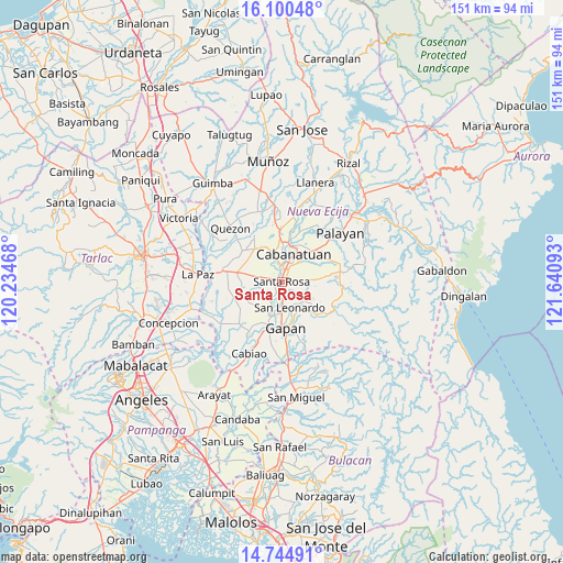
| Upper-left | 16.10048°, | 120.23468° |
| Center: | 15.4238°, | 120.9378° |
| Lower-right: | 14.74491°, | 121.64093° |
| Map W x H: | 150.7×150.7 km | = 93.6×93.6mi |
| max Lat: | 20.78733° ⇑19.1% North |
| Santa Rosa: | 15.4238° |
| min Lat: | ⇓80.9% South 4.65442° |
| min Long | Santa Rosa | max Long |
| 117.04868° | 120.9378° | 126.58417° |
| W 21.8%⇐ | ⇒78.2% E |
Elevation
Elevation of Santa Rosa is 31 m = 102 ft, and this is 56.9 m = 187 ft below average elevation for this country.
| Max E: |
2262 m = 7421 ft | 41.9% |
| Avg. | 87.9 m = 288 ft | |
| Santa Rosa | 31 m = 102 ft | |
Min E: |
-2 m = -7 ft | 58.1% |
See also: Philippines elevation on elevation.city.
Geographical zone
Santa Rosa is located in North Torrid zone (between Equator and Tropic of Cancer). Distance of this Northern Tropic circle is 891 km =553.6 mi to North.| Distance of | km | miles | from Santa Rosa |
|---|---|---|---|
| North Pole | 8292.1 | 5152.5 | to North |
| Arctic Circle | 5686.2 | 3533.2 | to North |
| Tropic Cancer | 891 | 553.6 | to North |
| Equator | 1715 | 1065.7 | to South |


Nearby cities:
15 places around Santa Rosa: (largest is in red/bold)
• Cabanatuan City
7.6 km =4.7 mi,  24°
24°
• Jaen
10.9 km =6.8 mi,  190°
190°
• Lambakin
10.1 km =6.3 mi,  234°
234°
• Lawang Kupang
12 km =7.5 mi, 225°
• Marawa
10.7 km =6.6 mi,  266°
266°
• Nieves
10.7 km =6.6 mi,  173°
173°
• Peñaranda
10.7 km =6.6 mi,  138°
138°
• Putlod
9.6 km =6 mi, 231°
• Rajal Norte
8.4 km =5.2 mi,  286°
286°
• San Anton
8.7 km =5.4 mi, 192°
• San Felipe Old
9.2 km =5.7 mi,  339°
339°
• San Leonardo
7.3 km =4.5 mi,  157°
157°
• Santo Rosario
5.3 km =3.3 mi,  282°
282°
• Soledad
4.9 km =3 mi,  84°
84°
• Tabuating
3.5 km =2.2 mi, 174°
Sources, notices
• [Note1] Compared only with cities in Philippines existing in our database
• [Src1] Map data: © OpenStreetMap contributors (CC-BY-SA)
• [Src2] Other city data from geonames.org with taken over terms of usage.
• [Src3] Geographical zone / Annual Mean Temperature by Robert A. Rohde @ Wikipedia
