Mabayo geodata
Mabayo (Central Luzon) is a populated place; located in Philippines in Asia/Manila (GMT+8) time zone. With population of 2,843 people, there are 2715 cities with bigger population in this country. Compared to other cities in Philippines, 75.4% of cities are located further ↓South; 95.6% of cities are located further →East and 76.6% of cities have higher elevation than Mabayo. Note1


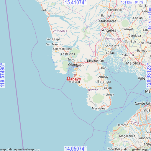
Mabayo GPS coordinates[2]
14° 43' 54.48" North, 120° 16' 41.16" East
| Map corner | latitude | longitude |
|---|---|---|
| Upper-left | 15.41074°, | 119.57498° |
| Center: | 14.7318°, | 120.2781° |
| Lower-right: | 14.05074°, | 120.98123° |
| Map W x H: | 151.2×151.2 km | = 94×94mi |
| max Lat: | 20.78733° ⇑24.6% North |
| Mabayo: | 14.7318° |
| min Lat: | ⇓75.4% South 4.65442° |
| min Long | Mabayo | max Long |
| 117.04868° | 120.2781° | 126.58417° |
| W 4.4%⇐ | ⇒95.6% E |
Elevation
Elevation of Mabayo is 10 m = 33 ft, and this is 77.9 m = 256 ft below average elevation for this country.
| Max E: |
2262 m = 7421 ft | 76.6% |
| Avg. | 87.9 m = 288 ft | |
| Mabayo | 10 m = 33 ft | |
Min E: |
-2 m = -7 ft | 23.4% |
See also: Philippines elevation on elevation.city.
Geographical zone
Mabayo is located in North Torrid zone (between Equator and Tropic of Cancer). Distance of this Northern Tropic circle is 967.9 km =601.4 mi to North.| Distance of | km | miles | from Mabayo |
|---|---|---|---|
| North Pole | 8369 | 5200.3 | to North |
| Arctic Circle | 5763.2 | 3581.1 | to North |
| Tropic Cancer | 967.9 | 601.4 | to North |
| Equator | 1638 | 1017.8 | to South |


Nearby cities:
15 places around Mabayo: (largest is in red/bold)
• Bagac
19.5 km =12.1 mi,  140°
140°
• Balsic
26.1 km =16.2 mi,  57°
57°
• Banawang
17.9 km =11.1 mi, 137°
• Castillejos
24 km =14.9 mi,  338°
338°
• Dinalupihan
24.8 km =15.4 mi,  48°
48°
• Morong
6 km =3.7 mi,  192°
192°
• Olongapo
10.8 km =6.7 mi,  2°
2°
• Pamatawan
22.9 km =14.2 mi, 342°
• Parang
21.4 km =13.3 mi,  120°
120°
• Sabang
5 km =3.1 mi,  215°
215°
• San Agustin
26.3 km =16.3 mi,  328°
328°
• San Benito
20.8 km =12.9 mi, 50°
• Saysain
22.6 km =14 mi,  147°
147°
• Subic
17.1 km =10.6 mi, 343°
• Subic Bay Freeport Zone
6.4 km =4 mi, 1°
Sources, notices
• [Note1] Compared only with cities in Philippines existing in our database
• [Src1] Map data: © OpenStreetMap contributors (CC-BY-SA)
• [Src2] Other city data from geonames.org with taken over terms of usage.
• [Src3] Geographical zone / Annual Mean Temperature by Robert A. Rohde @ Wikipedia
